
District Harz Elevation 490 m (1,610 ft) Area 27.39 km² | Time zone CET/CEST (UTC+1/+2) Local time Thursday 12:43 AM | |
 | ||
Weather 3°C, Wind W at 11 km/h, 99% Humidity Points of interest Harz, Elendstal, Schnarcherklippen, Elendsburg, Barenberg | ||
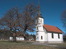
Elend is a district of the town of Oberharz am Brocken in the Harz District, in Saxony-Anhalt, Germany. It lies in the Bode valley in the High Harz in central Germany, at a height of 505 m above NN. This part of the valley is known locally as Elendstal. Elend is located near the former Inner German Border between West and East Germany.
Contents
Map of Elend, Germany
Geography
About 3 kilometres west of the village is the nature reserve of Kramershai.
History
Walther Grosse mentions fields under the Elend Road (unter dem elendischen Wege) for the first time in a manuscript of field names in the Amt of Elbingerode for 1483. In a Vogtei account for the Amt of Elbingerode (Harz) dated 1506/07 there is an entry which states: "Income from the sawmill at Elend in the Forest XII March" (Innome von der Sagemoln zum Elende deß Forst XII Mar[k]). There are a lot of indications that this sawmill had existed for some time before that.
On 1 January 2010, the municipality of Elend merged with the municipalities of Sorge, Stiege and Tanne, as well as the towns of Elbingerode (Harz), Hasselfelde and Benneckenstein (Harz), forming the town Oberharz am Brocken.
Hiking
Not far from Elend is the Helenenruh, a rocky ridge with outstanding views, which is checkpoint no. 21 in the Harzer Wandernadel hiking network.