
State Victoria Abolished 1856 Founded 1851 | Created 1851 Demographic Rural Date dissolved 1856 | |
 | ||
Area 41,000 km (15,830.2 sq mi) | ||
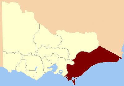
The Electoral district of Gipps' Land was one of the original sixteen electoral districts of the old unicameral Victorian Legislative Council of 1851 to 1856. Victoria being a colony in Australia at the time.
The area of Gipps' Land was defined as: "Bounded on the south and east by the sea on the north by a line running in a westerly direction from Cape Howe to the source of the nearest tributary of the Murray and the Australian Alps again on the west by the Alps and the Counties of Evelyn and Mornington."
From 1856 onwards, the Victorian parliament consisted of two houses, the Victorian Legislative Council (upper house, consisting of Provinces) and the Victorian Legislative Assembly (lower house).
Members for Gipps' Land
These were members in the unicameral Legislative Council of Victoria which existed from 1851 to 20 March 1856.