
Mountain type Table mountain Mountain range Sierra Maestra | Elevation 575 m | |
 | ||
Similar Gran Piedra, Pico Turquino, Blue Mountain Peak, Mount Alvernia, Pic la Selle | ||
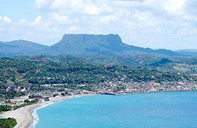
El Yunque is a 575-metre-high (1,886 ft) mountain located 7 km (4.3 mi) west of Baracoa and the Baracoa Bay in Cuba's Guantanamo Province. It has a table mountain shape that resembles an anvil ("yunque" in Spanish).
Contents
Map of El Yunque, Cuba
Overview
El Yunque was mentioned by Christopher Columbus in his chronicles about the discovery of the Americas. The Yunque is situated between the banks of the rivers Duaba and Toa, it is 1,125 m (3,691 ft) long and has a total area of 461,000 m2 (4,960,000 sq ft).
El Yunque was declared a National Monument by the Cuban National Commission of Monuments on December 25, 1979.
References
El Yunque (Cuba) Wikipedia(Text) CC BY-SA