Suvarna Garge (Editor)

El Fresno, Michoacán

Updated on
Edit
Like
Comment
Share on FacebookTweet on TwitterShare on LinkedInShare on Reddit
Country
  
Mexico

Foundation
  
1898

Elevation
  
1,960 m

State
  
Michoacán

Time zone
  
CST UTC-6

Postal code
  
59526

El Fresno, Michoacán

Area code(s)
  
+52 (Mexico) / +353 (Jiquilpan)

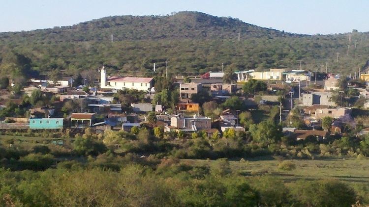
The small town of El Fresno is located in the North West of Jiquilpan, Mexican State of Michoacán de Ocampo and South West of Sahuayo, De Morelos, Michoacán.

Contents

Map of El Fresno, Michoac%C3%A1n, Mexico

The small Town has over 207 inhabitants.

It is over 1960 meters above sea level.

The small town is noticeable because of the Milk and Cheese, they also provide a Gas station Pemex, also some Abarrotes small stores. It has a connection between Road #110 to La Piedad and Manzanillo, Colima End Road.In the town overlooking the meadow vegetation with mesquite, cactus and yucca huisache, the mixed forest of pine, oak and cedar, also shrubs of different species. Features and Land Use lesser extent livestock and forestry. It is also known from crops and fields Corn and Chickpea. El Fresno also has a Soccer field, and a large "Presa" where people fishe's most of the time.

Nearby Cities & Towns

  • Abadiano
  • Guadalajara
  • Jiquilpan
  • Sahuayo
  • San José de Gracia
  • Manzanillo (Via #110 Route)
  • Valle de Juárez
  • Cerro San Francisco
  • La Jara
  • Los Remedios
  • Llano Prieto
  • La Lagunita
  • Paredones
  • Paso
  • Timbiscato
  • La Cantera
  • Totolán
  • Guadalupe
  • El Molino
  • San Onofre
  • Jaripo
  • Las Mesas
  • Las Ánimas
  • Cuesta
  • Brete
  • ^Jiquilpan de Juárez
  • Santa María
  • San Antonio Guaracha
  • Los Animas
  • San Juanico
  • Santa Bárbara
  • Maríano Escobedo
  • Capadero
  • Villamar
  • Lagunilla
  • La Huerta
  • La Yerbabuena
  • Casa Fuerte
  • All in Michoacán De Ocampo.

    Airports Near By

  • Zamora(ZMM), Zamora, Mexico (63.2 km)
  • Lic. Miguel de la Madrid Airport (CLQ), Colima, Mexico
  • Lic. y Gen. Ignacio Lopez Rayon National Airport(UPN), Uruapan, Mexico (131.7 km)
  • Don Miguel Hidalgo y Costilla International Airport (GDL), Guadalajara, Mexico (138.2 km)
  • Lic. Miguel de la Madrid Airport(CLQ), Colima, Mexico (178.4 km)
  • Cultural Foods

  • Birria
  • Tamales
  • Chile Relleno
  • Tacos
  • Festivals

  • March / April: Easter.
  • March 20: San Jose/ Funsion
  • March 18: Commemoration of the Petroleum Expropriation.
  • April 13: Anniversary of elevation to city status (1891)
  • May 21: Birthday of General Lázaro Cárdenas.
  • 7 August: Feast of San Cayetano.
  • October 4: Feast in Honor of St. Francis of Assisi.
  • Oct. 19: Commemoration of the death of General Lázaro Cárdenas.
  • November 20: Anniversary of the Mexican Revolution.
  • December 1–12: Fiesta of Nuestra Virgen Guadalupana, (Our Lady of Guadalupe).
  • Tour

  • Tourist info
  • Schools

    There's only (2) School's in the small town.

  • - Colegio Lazaro Cardenas (Telesecundaria Comunitaria El Fresno)
  • - Pre- Escolar
  • References

    El Fresno, Michoacán Wikipedia