
Gaelic name Eilean dà Mhèinn OS grid reference NR781944 Highest elevation 16 m (52 ft) Area 3 ha | Meaning of name island of two mines Council area Argyll and Bute | |
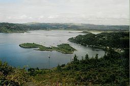 | ||
Eilean dà Mhèinn, is a small inhabited island in Loch Crinan and one of the Inner Hebrides of Scotland.
Map of Eilean d%C3%A0 Mh%C3%A8inn, United Kingdom
It is about 100 metres (330 ft) to the west of the village of Crinan in Knapdale at high tide and only a fraction of that distance from the mainland shore at low tide.
Although apparently not permanently inhabited in 2001 according to the 2011 census there was a single inhabitant at that time. It has a landing stage on the eastern shore and a building near the centre of the island. The crowded harbour at Crinan has so many moorings that "it is no longer possible to anchor to the south or east" of the island.
Eilean dà Mhèinn is part of the Knapdale National Scenic Area, one of 40 in Scotland.
References
Eilean dà Mhèinn Wikipedia(Text) CC BY-SA