
Construction masonry tower Characteristic Fl W 10s. Opened October 1833 Focal height 31 m Year first constructed 1833 | Intensity 71,000 candela Height 26 m Range 27,359 m Automated June 1965 | |
 | ||
Location Eilean MusdileFirth of LornScotland Tower shape cylindrical tower with balcony and lantern attached to 1-storey keepe's house Markings / pattern white tower and lantern, ochre trim Similar Lis Lighthouse, Firth of Lorn, Claig Castle, Cara Island, Calve Island | ||
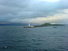
Eilean Musdile (Mansedale) is an islet, and lighthouse to the south west of Lismore in the Inner Hebrides.
Map of Eilean Musdile, United Kingdom
The island lies in the entrance to Loch Linnhe, separated from Lismore by a sound ¼ miles across. It is a low-lying rock, ten acres (4 ha) in size, with some grass on it. CalMac ferries pass close to the island on their way from Oban to Mull.
The lighthouse was built by Robert Stevenson in 1833 at a cost of £4260 and initially showed a fixed white light. In 1910 most of the Northern Lighthouse Board's lights were changed to dioptric or Fresnel lenses but Lismore and Fidra, in the Firth of Forth, were left as the only remaining purely catoptric lights in the service.
A Standing Stone once stood on the highest point of the island (NM779351). The 9-foot (2.7 m) monolith appears to have recorded the midwinter sunset and is thought to have been removed during construction of the lighthouse.
The skerry of Lady's Rock lies a short distance to the south west.