
Gaelic name Eilean Loain OS grid reference NR755854 Highest elevation 28 m (92 ft) Area 15 ha | Meaning of name pack of hounds isle | |
 | ||
Eilean Loain, is a small island in Loch Sween and one of the Inner Hebrides of Scotland.
Map of Eilean Loain, United Kingdom
It is about 2 kilometres (1.2 mi) west of the settlement of Kilmichael of Inverlussa in Knapdale and a similar distance southeast of the village of Tayvallich on the other side of the loch. It is attended by the islet of Cala that lies to the north west.
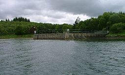
Eilean Loain has a substantial jetty on the north shore and a large building nearby and has been described as "inhabited" by Haswell-Smith (2004). Argyll and Bute Council records indicate the presence of a dwelling house and according to the National Records of Scotland census information the island is "included in the NRS statistical geography for inhabited islands but had no usual residents at the time of either the 2001 or 2011 censuses".
Eilean Loain is part of the Knapdale National Scenic Area, one of 40 in Scotland.