
Gaelic name Eilean Dubh Mòr OS grid reference NM695105 Highest elevation 53 m Area 50 ha | Meaning of name big black island Area rank 199= Council area Argyll and Bute | |
 | ||
Island groups British Isles, Slate Islands, Inner Hebrides | ||
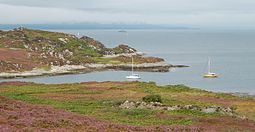
Eilean Dubh Mòr (Scottish Gaelic: big black island) is an uninhabited island in the Inner Hebrides of Scotland. It lies at the mouth of the Firth of Lorn, between the islands of Lunga and Garbh Eileach. The area of the island has been measured variously—at 50 hectares (120 acres) by Livingstone and 65 hectares (160 acres) by Haswell-Smith, the latter including the nearby islet of Eilean Dubh Beag (Scottish Gaelic: small black island), which is joined to Eilean Dubh Mòr at low stages of the tide.
Map of Eilean Dubh Mor, United Kingdom
References
Eilean Dubh Mòr Wikipedia(Text) CC BY-SA