
Population 3,735 (2011) Postal code 4305 | Postcode(s) 4305 | |
 | ||
Location 40 km (25 mi) from Brisbane3 km (2 mi) from Ipswich | ||
Eastern Heights is a residential suburb of Ipswich, Queensland, Australia. It is bordered to the west by Queens and Limestone Park. At the 2011 Australian Census the suburb recorded a population of 3,735.
Contents
- Map of Eastern Heights QLD 4305 Australia
- Transport
- Education
- Parks and sports facilities
- Places of worship
- Heritage listings
- References
Map of Eastern Heights QLD 4305, Australia
The origin of the suburb name is from a high ridge on the eastern side of the Ipswich CBD.
Transport
Eastern Heights is serviced by a regular bus service.
Education
There are no schools in Eastern Heights, Silkstone Primary lie just to the east in Silkstone, while Ipswich Central Primary lie just to the west. Bremer State High School used to lie in the east as with Skilstone Primary, but has since moved further south-west of the suburb.
Parks and sports facilities
Places of worship
Heritage listings
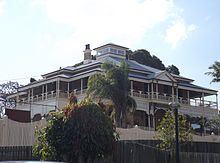
Eastern Heights has a number of heritage-listed sites, including:
References
Eastern Heights, Queensland Wikipedia(Text) CC BY-SA