
Bridges Russky Bridge | ||
 | ||
Similar Russky Bridge, Zolotoy Rog, Zolotoy Bridge, Popov Island, Shkot Island | ||
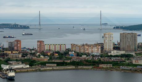
Eastern Bosporus (or Eastern Bosphorus, Russian: Босфор Восточный, Bosfor Vostochny) is a strait that separates the Muravyov-Amursky Peninsula and Russky Island, and connects Amur Bay and Ussuri Bay.
Map of Eastern Bosphorus, Russia, 690063
The depth is up to 50 m. It is about 9 km long and only 800 m wide at its narrowest point. Completed in July 2012, Russky Bridge, a cable-stayed bridge connects Russky Island and mainland Vladivostok. As of 2013, the bridge is the longest cable-stayed bridge in the world by virtue of its span of 1104 m.
References
Eastern Bosphorus Wikipedia(Text) CC BY-SA