
OS grid reference SU946055 Sovereign state United Kingdom Local time Friday 11:18 AM Dialling code 01243 UK parliament constituency Arundel and South Downs | Civil parish Eastergate Area 3.7 km² District Arun | |
 | ||
Population 3,107 2001 Census3,417 (2011 Census) Weather 9°C, Wind SE at 11 km/h, 99% Humidity | ||
Eastergate is a village and civil parish in the Arun District of West Sussex, England. It is located five miles (8 km) east of Chichester. The civil parish covers an area of 370ha (of which 200ha is owned by the farm) and has a population of 3107 persons (2001 census). At the 2011 Census the population was 3,417.
Map of Eastergate, UK
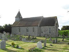
Roman remains have been found near St George's Church, although until the 20th century the village remained a small one. The area, being on alluvium, was principally used for market gardens. Subsequent house building has resulted in a large increase in population.
John Ireland (1879–1962) often stayed in the parish, and named a hymn tune after it.
Barnham railway station (which is actually within Eastergate parish) was opened in 1864 and lies on the West Coastway Line. The station was called Barnham Junction until 1929 because the branch line to Bognor Regis leaves the main line here. East and West Coastway (to Brighton in the East and Portsmouth in the West) and London services are operated by Southern, with South West Trains and First Great Western travelling as far afield as Reading and Cardiff.