
Population 273. 2011 Census Civil parish East Lavington Area 7.97 km² UK parliament constituency Chichester | OS grid reference SU946162 Sovereign state United Kingdom Dialling code 01798 | |
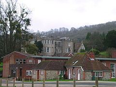 | ||
East Lavington, formerly Woolavington, is a village and civil parish in the District of Chichester in West Sussex, England. It is located six kilometres (4 miles) south of Petworth, west of the A285 road.
Map of East Lavington, UK
West Lavington was formerly an exclave of Woolavington.
The parish has a land area of 797 hectares (1968 acres). In the 2001 census 357 people lived in 87 households, of whom 129 were economically active. It includes the settlement of Upper Norwood.
The parish is dominated by Seaford College, a private school which owns 400 acres (1.6 km2). The ancient parish church has become the school chapel.
References
East Lavington Wikipedia(Text) CC BY-SA