
Country United States County Allegheny County ZIP Code 15212 Area 61 ha Architectural style Victorian architecture | State Pennsylvania City Pittsburgh NRHP Reference # 83004181 Population 2,136 (2010) Added to NRHP 25 November 1983 | |
 | ||
Restaurants James Street Gastropu, Bistro To Go, Max's Allegheny Tavern, Huszar, Legends of the North Shore | ||
East Allegheny, also known as Deutschtown, is a neighborhood on Pittsburgh's North Side. It has a ZIP Code of 15212, and has representation on Pittsburgh City Council by the council member for District 1 (North Central Neighborhoods). The Pittsburgh Bureau of Fire houses 32 Engine and 32 Truck in Deutschtown.
Contents
- Map of East Allegheny Pittsburgh PA 15212 USA
- History
- Geography and transportation
- Organization
- References
Map of East Allegheny, Pittsburgh, PA 15212, USA
History
In 1783, the Commonwealth of Pennsylvania established a 3000-acre tract of land north of where the Allegheny River merged with the Ohio River. John Redick created an initial town plan for Allegheny City – which featured 36 city blocks surrounded by a common grazing area – the following year. The common grazing area became a park now known as Allegheny Commons, and the area just east of the park – which had been set aside for farming in Redick's initial plan – is today's East Allegheny.
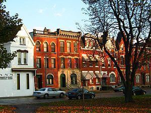
This area was developed between 1850 and 1900 by immigrants who were almost exclusively German. As a result, the area was called Dutchtown, a mispronunciation of Deutschtown. Its residents created a business district on East Ohio Street and a residential district running south of it, from Cedar Street (on the western border with Allegheny Commons) to Troy Hill (on the east). These buildings were very solidly built.
In 1984, this area was listed on the National Register of Historic Places as the Deutschtown Historic District. The nominating petition noted that "Dutchtown is distinguished from neighboring North Side neighborhoods by its ethnic associations and intense feeling of neighborhood solidarity. It also retains the busiest original commercial district left on the North Side since the development of Allegheny Center in the 1960's." The area is also a City of Pittsburgh Historic District.
Construction of Interstate 279 sliced the neighborhood in half, such that there is now a West Deutschtown (which runs from Allegheny Commons to the Interstate and contains the active business district on East Ohio Street) and an East Deutschtown (which runs from the Interstate to Troy Hill). Both sections of the neighborhood suffered as a result of the Interstate's construction: some residents moved, their homes were rented by absentee landlords to low-income tenants, and the area saw a general lack of investment. However, neighborhood activists established the East Allegheny Community Council and gradually restored the neighborhood, especially the western portion.
Geography and transportation
East Allegheny is composed of "East Deutschtown," an area that is bounded by East Street, East Ohio Street, Goehring Street and Vinial Streets, and "West Deutschtown," which extends from Cedar Avenue to East Street and from the Norfolk Southern Mainline to Dunloe Street.
Surrounding neighborhoods include Allegheny Center, Fineview, Troy Hill, Spring Hill, and Spring Garden.
City buses that connect East Allegheny and downtown include 500, 16B, 16F, 1D, 1F, 6A and 12A. 54C also connects East Allegheny with Oakland, the city's academic center.
Organization
The neighborhood citizens group is the East Allegheny Community Council. The organization offers a self-guided walking tour for the neighborhood (available from its website).