
Lowest pressure 936 mb (27.64 inHg) | Lowest temperature -2°F(Post-storm) | |
 | ||
Type Extratropical cyclone
Nor'easter
Winter storm Formed December 30, 2013 (2013-12-30) Dissipated January 6, 2014 (2014-01-06) Maximum snowfall or ice accretion 23.8 in (0.60 m) in Boxfield, Massachusetts | ||
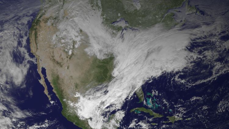
The Early January 2014 nor'easter was a major winter storm that affected much of the East Coast with snow, and frigid temperatures following the storm. The storm had dumped up to 2 feet (0.61 m) of snow in some areas, especially around Boston, Massachusetts.
Contents
Meteorological synopsis
Late on December 30, a weak clipper system moved southward from Canada. The system produced light snow in the Midwest around areas like Minneapolis, Minnesota with only light accumulations.
Starting on New Year's Day, however, the clipper began to strengthen and take an eastward turn. It would produce more moderate to heavy snow around areas like Cincinnati, Ohio, with accumulations of roughly 4-6 inches. The storm then continued to move eastwards towards the East Coast, where it would continue to intensify.
Early on January 2, the system started to become more complex as a new low pressure area had formed in the Gulf of Mexico along a stationary front. Winter storm warnings began to be issued by roughly mid-day from eastern New England to as far west as Pennsylvania as the storm closed in on the Northeast. By 3:00 p.m, the northern low began to weaken as the southern one began to take over as it continued to pull moisture from the Gulf of Mexico. This was the start of the storm's transition to a nor'easter.
Later that night, the low pressure began to strengthen off the Southeast coast and move out to sea as it dumped snow on its northwestern side over the Northeastern United States and New England. Snow continued to fall into the early hours of January 3 even as it pulled away from the coastline.
After it had left the coast early that morning, it continued to strengthen and turn to the northeast, and late on January 4, it reached its peak intensity of 936 millibars (27.6 inHg) while situated near Greenland. It was then absorbed into another extratropical cyclone.
Aftermath and cold wave
After the storm passed, an arctic front associated with it passed through the region, bringing record cold temperatures in the eastern half of the United States.
On January 3, Boston had a temperature of 2 °F (−17 °C) with a −20 °F (−29 °C) wind chill, and over 7 inches (180 mm) of snow. Boxford, Massachusetts recorded 23.8 inches (600 mm). Fort Wayne, Indiana had a record low of −10 °F (−23 °C). In Michigan, over 11 inches (280 mm) of snow fell outside Detroit and temperatures around the state were near or below 0 °F (−18 °C). New Jersey had over 10 inches (250 mm) of snow, and schools and government offices closed. Over a dozen deaths were attributed to the cold wave, with dangerous roadway conditions and extreme cold cited as causes.
Evan Gold of weather intelligence firm Planalytics called the storm and the low temperatures the worst weather event for the economy since Hurricane Sandy just over a year earlier. 200 million people were affected, and Gold calculated the impact at $5 billion. $50 to $100 million was lost by airlines which cancelled a total of 20,000 flights after the storm began on January 2. JetBlue took a major hit because 80 percent of its flights go through New York City or Boston. Tony Madden of the Federal Reserve Bank of Minneapolis said with so many schools closed, parents had to stay home from work or work from home. Even the ones who could work from home, Madden said, might not have done as much. Not included in the total were the insurance industry and government costs for salting roads, overtime and repairs..