
Lowest pressure 976 mbar (28.8 inHg) | ||
 | ||
Type Extratropical cyclone
Winter storm
Nor'easter
Blizzard
Bomb cyclone Formed February 7, 2016 (2016-02-07) Dissipated February 10, 2016 (2016-02-10) Highest gust 65 mph (105 km/h) at Nantucket Island, Massachusetts Maximum snowfall or ice accretion 11 in (0.28 m) at East Falmouth, Massachusetts | ||
The Early February 2016 nor'easter was a potent nor'easter moved up the east coast, causing more snow to the already-weary Northeast United States after the leading edge of the previous system and the historic blizzard of January 21–23. The storm dropped up to 12 in (0.30 m) of snow in parts of New England. Strong wind gusts were also reported along the eastern edge of New England.
Contents
Meteorological history
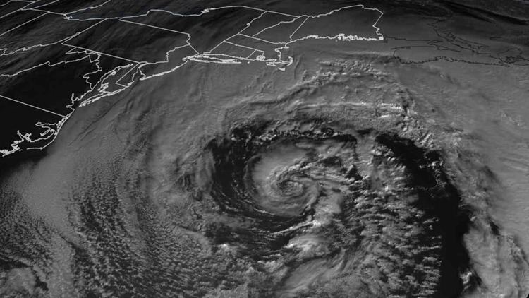
On February 7, an elongated area of low pressure developed offshore to the west of Florida. While moving inland, it produced a decent dose of rainfall to the Sunshine State as it moved to the northeast. Later the same day, it moved offshore into the Atlantic Ocean and began to undergo bombogenesis, it's pressure dropping from 1,004 millibars (29.6 inHg) at 7 a.m EST February 7 to 979 millibars (28.9 inHg) at 1 a.m EST February 8. As it did so, it also began to transition into a nor'easter, as rainbands began to impact the eastern edges of North Carolina and South Carolina. There was some cold air aloft, allowing for a few areas of wet snow to develop further inland.
As the cyclone continued to strengthen, it started to achieve the conditions of a bomb cyclone. Furthermore, the system started to form an eye compared to that of a typical Category 1 hurricane, however this was short-lived and dissolved a few hours later. Snowbands began to impact New England early in the morning of February 8, with some bands reaching up to snowfall rates of an inch per hour, especially near the coast. The outermost bands did not reach New Jersey and New York City, due to the nor'easter being far offshore. The storm continued to deepen for a few more hours before reaching its peak intensity of 976 millibars (28.8 inHg). The system then continued to weaken as it moved northward, before finally merging with another low pressure system on February 10 to the south of it which had also exited from the East Coast.
Snowfall totals
The following is a list of snowfall totals from the system.
Source: