
Topo map USGS Eagle Cap Elevation 2,918 m | Easiest route Scramble Prominence 369 m | |
 | ||
Similar Sacajawea Peak, Aneroid Mountain, Chief Joseph Mountain, Mount Howard, Strawberry Mountain | ||
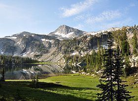
Eagle Cap (9,577 feet (2,919 m) is a mountain peak located in the Wallowa Mountains, Wallowa-Whitman National Forest, in the U.S. state of Oregon. The peak is in the Eagle Cap Wilderness and the Benson Glacier is along the east flank of the summit ridge. Its summit is the highest point in Union County
Map of Eagle Cap, Oregon 97857, USA
References
Eagle Cap Wikipedia(Text) CC BY-SA