
Population 264 (2011 census) Postal code 2529 Federal division Division of Gil | Postcode(s) 2529 Parish Terragong 1858 | |
 | ||
Dunmore is a largely rural suburb of Wollongong in New South Wales, Australia. Dunmore is bisected north to south by the South Coast railway line and the Princes Highway.
Map of Dunmore NSW 2529, Australia
Much of the present-day City of Shellharbour was originally part of the 13,000-acre Peterborough Estate, granted to discharged convict and colonial politician D'Arcy Wentworth in 1821. In 1865, a 2,560-acre portion of the estate was advertised for sale. The land stretched along the Minnamurra River in the south of the estate, towards Jamberoo. Local shopkeeper George Lawrence Fuller bought the property and named it Dunmore after his birthplace in County Galway, Ireland. (Fuller's son George was to become Premier of New South Wales in 1921.) Fuller père was instrumental in the development of basalt quarrying in the district.
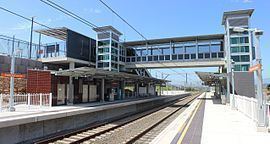
Dunmore came to prominence in 1887 as the location of the railway station serving the seaside village of Shellharbour, five kilometres to the north-east. Indeed, at various times, the station was known as "Shellharbour". The station moved from its original location at Dunmore Road, in the suburb's south, to be closer to the centre of Shellharbour, in 2014. The new station is known as Shellharbour Junction. Dunmore is also home to a Boral basalt quarry, opened c. 1900, and Shellharbour Anglican College, which opened in 2004.