
 | ||
Similar Thomas Bay, Revillagigedo Island, Chatham Strait, Chichagof Island, Tongass National Forest | ||
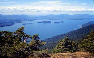
The Duncan Canal is a naturally occurring inland waterway in the Alexander Archipelago in Alaska, USA. It deeply penetrates Kupreanof Island, separating the Lindenberg Peninsula, on the southeast side of the island from the main island. It was first charted in 1793 by James Johnstone, one of George Vancouver's officers during his 1791-95 expedition. It was named after the English missionary William Duncan.
Map of Duncan Canal, Alaska 99833, USA
The Duncan Canal Portage is a popular hiking trail across the northern end of the Lindenberg Peninsula. It originally provided access to the northern end of the Duncan Canal directly from Frederick Sound.
Butterworth Island is located at the mouth of the Duncan Canal where it debouches into the Sumner Strait past the larger Woewodski Island.