
Population 12,981 (2011 census) Postcode(s) 2203 State electorate(s) Summer Hill Founded 1892 | Established 1892 LGA(s) Inner West Council Area 210 ha Postal code 2203 | |
 | ||
Location 7.5 km (5 mi) inner-west of Sydney CBD Federal divisions Division of Barton, Division of Grayndler | ||
Dulwich Hill is a suburb in the Inner West of Sydney, in the state of New South Wales, Australia 7.5 kilometres south-west of the Sydney central business district, in the local government area of Inner West Council. Dulwich Hill stretches south to the shore of the Cooks River.
Contents
- Map of Dulwich Hill NSW 2203 Australia
- History
- Commercial area
- Education
- Tram history
- Modern transport
- Demographics
- Notable people
- Governance
- Sport and recreation
- Houses
- Churches
- References
Map of Dulwich Hill NSW 2203, Australia
History
The suburb takes its name from the area of Dulwich in London. The name Dulwich Hill appears in Sands Directory of 1892. It had been known by several different names prior to this. Following European settlement, it was called Petersham Hill. It later took the name Wardell's Bush, a reference to Dr Robert Wardell, one of the area's early landowners. Other names the area was given were South Petersham and Fern Hill.
The area became part of Sydney's expanding tram network in 1889 and, like many suburbs in the inner-west, experienced rapid growth in the early twentieth century. As a consequence, the suburb has a large number of examples of Australian Federation architecture. It also features examples of Edwardian, Gothic and Italianate architecture. The tramway ran up until 1957.
Listed on the Register of the National Estate is the former public school in Seaview Street, which now operates as the Dulwich Hill High School of Visual Arts and Design. The building was designed by W.E.Kemp in the Romanesque style and built circa 1892. Situated in the same street is the Dulwich Hill Library, a converted cottage in the Victorian Gothic style.
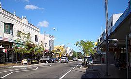
Commercial area
Dulwich Hill features two shopping areas, a small number of shops on Wardell Road near Dulwich Hill railway station and the main shopping area around the northern end of Marrickville Road and its intersection with New Canterbury Road. The Marrickville Road shopping area centred on the former tram line (now replaced by buses), and continues onto New Canterbury Road. In the 1990s many shops were vacant, but in recent years most shops have tenants with thriving businesses. Cafés and restaurants have become popular as the suburb becomes gentrified. Marrickville Council upgraded the shopping strip in the early 2000s, enhancing the look and character of the area. Dulwich Hill has a library (a branch of Marrickville Library) and a post office, but was never chartered a town hall or police station (the nearest is Marrickville Local Area Command).
Education
Dulwich Hill contains three primary schools: Dulwich Hill Public School in Kintore Street, St Maroun's College in Wardell Road and St Paul of the Cross, a Catholic school in New Canterbury Road, as well as one secondary school, Dulwich High School of Visual Arts & Design in Seaview Street. Dulwich High School was the first Visual Arts School in Australia.
Notable graduates of the high school include former Parramatta rugby league coach Terry Fearnley, tennis player Phil Dent and opera singer Yvonne Minton, while former rugby league referee Jack Danzey taught there.
Tram history
Until the late 1950s, when the local tramway system was closed, electric trams ran to Dulwich Hill and the Cooks River from Circular Quay. The line to Dulwich Hill branched from the Cooks River line at Newtown, turning off King Street into Enmore Road, travelling through Marrickville and Dulwich Hill, via Victoria and Marrickville Roads. A tram tuning loop was provided at the Canterbury Road terminus.
Modern transport
Modern public transport to the area comprises one railway station, four light rail stops and several bus routes.
Dulwich Hill railway station is located on Wardell Road, in the southern part of the suburb. The station is serviced by the Bankstown Line of the Sydney Trains network which provides reasonably frequent services to the Sydney CBD and south-western suburbs. Travelling west, residents can visit Bankstown and beyond to Liverpool and Lidcombe (a junction servicing several lines).
The Dulwich Hill Line of Sydney's light rail network includes four stations located in the suburb. These are - Dulwich Hill (adjacent to the railway station), Dulwich Grove (between New Canterbury Road and Hercules Street), Arlington (adjacent to Johnson Park near Constitution Road) and Waratah Mills (near Davis Street). Access to the city is quicker by train, but the light rail may be used for some cross-regional journeys. The service also interchanges with Lewisham railway station on the Airport, Inner West & South Line.
The 426, 428 and 412 routes provide bus connections between Dulwich Hill and the Sydney CBD. The 426 is the suburb's main bus route, starting at the corner of Marrickville and New Canterbury Roads and running along Marrickville Road towards Marrickville. The 428 service runs from Canterbury Station along New Canterbury Road towards Petersham. Both routes merge at Enmore and proceed to the city via Newtown. The 412 runs from Campsie to the city. It comes up Wardell Road, passing Dulwich Hill railway station, before running along the south side of the railway and proceeding up Livingstone Road towards Marrickville and Petersham. In the CBD, all routes proceed up Elizabeth Street and terminate at Martin Place.
Other routes serving the suburb are the 444/445, 418 and 425. The 444/445 routes run from Campsie Station to Balmain via Leichhardt, following the same route as the 428 through Dulwich Hill. The 418 between Bondi Junction and Burwood via Ashfield follows the same route as 426 between Marrickville and Dulwich Hill shops, before swinging on to New Canterbury Road, and then south to Hurlstone Park Station. The 425 follows the same route as the 426 to Marrickville, before heading to Tempe. It only operates during daytime hours on weekdays and Saturdays. All routes are operated by the State Transit Authority.
Demographics
According to the 2011 census, 12,981 residents in Dulwich Hill. Less than half (43.6%) of residents are immigrants with the top countries of birth being Greece 3.6%, England 3.5%, New Zealand 2.4%, Vietnam 2.0% and Portugal 1.6%. The dwellings in Dulwich Hill were a mix of separate houses (36.1%), Semi-detached (10.1%) and flats or apartments (52%).
Notable people
Governance
Residents of Dulwich Hill elect representatives to federal, state and local governments. At the federal level, it is in the electoral division of Grayndler, currently held by Anthony Albanese, of the Australian Labor Party (ALP), who was last re-elected in the 2007 General Election and has been named as a member of the Cabinet in the Rudd Government as the Minister for Infrastructure, Transport, Regional Development and Local Government. The seat of Grayndler has been held continuously by the ALP since it was proclaimed in 1949.
At the state level, Dulwich Hill is in the Electoral district of Summer Hill, which has been held by the ALP's Jo Haylen since its creation at the 2015 election.
At the local level, Dulwich Hill is in the west ward of Marrickville Council, represented by three councillors: Marika Kontellis, a member of the Australian Greens, Dimitrios Thanos, a local dentist and independent councillor first elected in 1999, and Emanuel Tsardoulias from the Australian Labor Party.
Sport and recreation
Arlington Recreation Ground in Williams Parade is home to the Dulwich Hill FC soccer club, which plays in the NSW Super League, the second tier of senior soccer in Sydney, and also the Stanmore Hawks soccer club which plays in the NSW State League Division One, the third tier.
Houses
Dulwich Hill is an established residential area with many examples of Federation architecture. The streets are wider than many inner-city suburbs and houses are bigger than some older, neighbouring suburbs such as Petersham. However, the area is also zoned for medium-density housing, with several blocks of flats having been built in the last forty years.
Churches
The area is served by several religious organisations, including Anglican, Catholic and Greek Orthodox churches.