
Opening date 1949 Width (base) 480 feet (150 m) Height 38 m Length 2,987 m | Opened 1949 Total capacity 1.573 km³ | |
 | ||
Catchment area 278.3 square miles (721 km) Similar | ||
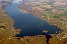
Dry Falls Dam is a rockfaced earthfill type dam in the U.S. state of Washington. Located in Grant County near Coulee City, it was built as part of the Bureau of Reclamation's Columbia Basin Project. Water from the Columbia River, impounded by Grand Coulee Dam, is pumped into Grand Coulee, a formerly dry canyon, through the short Feeder Canal. Grand Coulee's north end is sealed by North Dam and Dry Falls Dam stretches across the midsection of the Coulee. This allows the water pumped from the Columbia River to fill the upper Grand Coulee, creating a large equalizing reservoir known as Banks Lake. Water from the reservoir is fed into the irrigation project's Main Canal, which runs south from Dry Falls Dam to another reservoir called Billy Clapp Lake, formed by Pinto Dam.