
Irish Grid Reference O158368 | Elevation 25 m | |
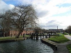 | ||
Drumcondra (Irish: Droim Conrach, meaning "Conra's Ridge") is a residential area and inner suburb on the Northside of Dublin, Ireland. It is administered by Dublin City Council. The River Tolka and the Royal Canal flow through the area. Drumcondra is also a parish in the Fingal South West deanery of the Roman Catholic Archdiocese of Dublin.
Contents
- Map of Drumcondra Dublin Ireland
- History
- Local government and subdivisions
- Transport
- Features
- Primary schools
- Secondary Schools
- Third level
- Religion
- Sport
- People
- References
Map of Drumcondra, Dublin, Ireland
History
The village of Drumcondra was the central area of the Parish of Clonturk, and the two names were used equally for the religious and civil parishes, but the new suburban district of Drumcondra now also encompasses the old Parish of St.Mary.
The Cat and Cage Pub on the Drumcondra Road was the site of an old postal stop and the point at which rebels, during the 1798 rebellion, seized a postal cart in order to signal to others in north County Dublin to revolt. The Cat and Cage is located at the corner of Church Avenue.
Local government and subdivisions
The Drumcondra, Clonliffe, and Glasnevin Township Act 1878 was a local act of the UK Parliament sponsored by businessmen in Drumcondra to create a township, called Drumcondra, Clonliffe, & Glasnevin, encompassing Drumcondra and the neighbouring districts of Clonliffe and Glasnevin, governed by town commissioners. The portion of the electoral division of Drumcondra outside the township was renamed Drumcondra Rural. The Dublin Boundaries Act 1900 absorbed the township into Dublin county borough as the wards of Drumcondra and Glasnevin. Part of Drumcondra Rural electoral division was transferred to the city in 1930. The remainder was split into Drumcondra Rural Number One and Drumcondra Rural Number Two in 1971.
Transport
Features
One of the main sights of Dublin is Croke Park, where Ireland's national games of Gaelic football and hurling may be seen. Boasting a capacity for 82,300 people, it is one of the largest sports stadiums in Europe. 'Croker' (as it colloquially known) is the headquarters of the Gaelic Athletic Association and also houses the official GAA Museum (on St Josephs Avenue, which is off Clonliffe Road). The stadium has the right to host the final matches of the All-Ireland Senior Football Championship and All-Ireland Senior Hurling Championship. The stadium is a 20-minute walk from Dublin city centre, or a 5-minute bus ride.
Fagan's Public House, Drumcondra Road Lower. Bertie Ahern took U.S. President, Bill Clinton, here in September 1998.
Kennedys Pub on Lower Drumcondra Rd is one of the oldest pubs in Drumcondra, predating Fagans by a number of years. Formerly called McPhilips, its been named Kennedys since 1961.
Tolka Park the home of League of Ireland side Shelbourne is situated on Richmond Road.
The National Council for the Blind at Whitworth Road, is located near the Church of St. George cemetery.
Primary schools
Secondary Schools
Third level
Three colleges associated with the Roman Catholic Church and Dublin City University are located in Drumcondra:
Religion
The oldest church in the district is Drumcondra Church (Church of Ireland), located at the bend of Church Avenue, abutting All Hallows College. Several notable people including Georgian-period architect James Gandon are buried in the adjoining graveyard.
The "Old Church of St.George" was built about 1668 in Lower Temple Street (changed to Hill Street in the 1800s), then a part of Drumcondra. The Tower of the Old Church of St. George can still be seen in Hill Street and its gravestones are around the walls of what is now a playground.
The "New Church of St.George" was built on the square further up the road at the end of Temple Street in the early 1800s. The original site acquired for the new church was on Whitworth Road, but then the present site was selected, which at the time was open fields. A temporary chapel was built on the Whitworth Road site and its churchyard was retained when St. George's was completed - this site was later taken over by the Whitworth Hospital (later named Drumcondra Hospital). The gravestones can be seen behind the Hospital.
In the Catholic church, Drumcondra is served by the Church of Corpus Christi at Home Farm Road. The palace of the Roman Catholic Archbishop of Dublin is situated alongside Clonliffe College (the diocesan seminary). Together they occupy an extensive site bounded by Clonliffe Road and the Drumcondra Road (to the South and West) with the River Tolka at the northern extremity.
The Respond! Housing Association has its Dublin office located in High Park, Drumcondra, where it also runs training courses in Housing and Social care provision.
Sport
Drumcondra is home to Croke Park and Tolka Park soccer stadium, the permanent home of Shelbourne F.C. since 1989, 'The Reds' have hosted major European clubs such as Panathinaikos and Steaua Bucharest in the Drumcondra venue. The Club has won the league six times and the FAI Cup four times since moving to Tolka Park. The park was also the base for Drumcondra F.C. (Drums) which was a League of Ireland club from 1928-1972 before it was merged with fellow Dublin club Home Farm, now based in nearby Whitehall. Drumcondra FC, who played their home games at Tolka Park stadium, was a successful side in the post World War II years, winning five Irish league titles between 1948 and 1965 as well as competing in the European Cup and Inter-Cities Fairs Cup on several occasions.
The name lives on today in the shape of Drumcondra FC.
The Ierne Sports Club is situated off Grace Park Road, Rosmini Gaels (GAA) is also based in Drumcondra.