
County Eagle FIPS code 08-21155 Elevation 1,874 m Population 705 (2010) | Time zone Mountain (MST) (UTC-7) GNIS feature ID 174006 Zip code 81637 Local time Friday 1:12 PM | |
 | ||
Weather 18°C, Wind W at 29 km/h, 18% Humidity Area 4.144 km² (3.626 km² Land / 52 ha Water) | ||
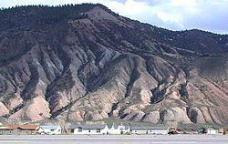
Dotsero volcano lava flow remnants at dotsero colorado
Dotsero is an unincorporated community and census-designated place (CDP) in western Eagle County, Colorado, in the United States. The population as of the 2010 Census was 705. The town originated as a railroad junction and is located at the confluence of the Eagle River with the Colorado River, along U.S. Highway 6 and Interstate 70, near the head of Glenwood Canyon, approximately 5 miles (8 km) west of Gypsum. The town consists mostly of a cluster of houses and trailers on both sides of the Eagle River.
Contents
- Dotsero volcano lava flow remnants at dotsero colorado
- Map of Dotsero CO 81637 USA
- Adams lake dotsero colorado
- Railroad
- Volcano
- References
Map of Dotsero, CO 81637, USA
Adams lake dotsero colorado
Railroad
Dotsero was an important railroad junction point for the Denver and Rio Grande Western Railroad's Denver to Salt Lake City line. Originally the line passed through Dotsero following the Eagle River towards Tennessee Pass and through the Royal Gorge of the Arkansas River in route to Pueblo, Colorado before turning north towards Denver. Through the years, efforts were made to have a more direct connection between Denver and Salt Lake that did not require detouring through Pueblo. The Denver and Salt Lake Railroad (D&SL) built a line west from Denver and entered the Colorado River canyon near Bond, Colorado, about 40 miles (64 km) Northeast of Dotsero. The D&SL was never finished as a separate route to Salt Lake City; however, was eventually acquired by the D&RGW, who built a connection between Dotsero and Orestod (Dotsero spelled backwards) near Bond. This connection, commonly known as the Dotsero Cutoff, was completed on June 15, 1934 and finally provided Denver with a direct link to Salt Lake City, making Dotsero the junction between the old and new routes to Denver. After completion the old route over Tennessee pass remained in use as a secondary route, but has been dormant since 1997.
Ferdinand Hayden published an extensive survey of central and southwest Colorado in 1877, and used the location of the town of Dotsero as his "Dot Zero" (reference point) for his survey maps. The station name exists from the construction of the standard gauge railroad line to Glenwood Springs in the 1890s.
Volcano
Dotsero is built at the base of Colorado's most recently active volcano, the Dotsero Crater, which, according to the United States Geological Survey, erupted 4,140 years ago.
The main industry at Dotsero for years consisted of making cinderblocks from the volcano.