
Local time Friday 6:21 PM | Elevation 109 m | |
 | ||
Weather 6°C, Wind SW at 8 km/h, 86% Humidity Voivodeship Warmian-Masurian Voivodeship | ||
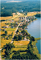
Dorotowo [dɔrɔˈtɔvɔ] (German: Dorothowo; 1913–1945:Darethen) is a village in the administrative district of Gmina Stawiguda, within Olsztyn County, Warmian-Masurian Voivodeship, in northern Poland. It lies approximately 5 kilometres (3 mi) north of Stawiguda and 11 km (7 mi) south-west of the regional capital Olsztyn.
Map of Dorotowo, Poland
While traditionally Prussian, with the Second Peace of Thorn in 1466 the area became part of the Kingdom of Poland until 1772; 1772–1945 Kingdom of Prussia and Germany (East Prussia).
References
Dorotowo, Warmian-Masurian Voivodeship Wikipedia(Text) CC BY-SA