
Primary inflows Catchment area 567 km (219 sq mi) Surface elevation 104 m Width 8 km Length 114 km Inflow source Dnieper | Primary outflows Dnieper River Max. length 114 km (71 mi) Area 567 km² Volume 2.45 km³ Outflow location Dnieper | |
 | ||
Type Hydroelectric reservoir Basin countries Russia, Belarus, Ukraine | ||
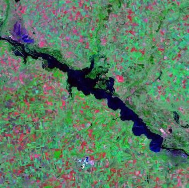
The Dniprodzerzhynsk Reservoir (Ukrainian: Дніпродзержинське водосховище, Dniprodzerzhyns'ke vodoskhovyshche) is a water reservoir located on the lower part of the Dnieper River in Ukraine. Named after the former name of the city of Kamianske (on 19 May 2016 the Ukrainian parliament voted to rename the city of Dniprodzerzhynsk into Kamianske to comply with decommunization laws), it covers a total area of 567 square kilometres within the Dnipropetrovsk Oblast. It was formed in 1963-1965. The reservoir is mainly used for generating hydroelectric power, transportation, fish farming, and human consumption
Map of Dniprodzerzhyns'ke Reservoir, Ukraine
The reservoir is 114 km in length, 5 km in width (8 km max.); has a depth of 15 meters, and a volume of 2.45 km³. During winter, the reservoir freezes over.
The ports of Kremenchuk and the Dnieper Mineral Enrichment Complex in Horishni Plavni are located on the reservoir. The Dniprodzerzhynsk Hydroelectric Station, constructed during 1956–1965, is also located on the reservoir.