
Created 1949 Electors 99,329 (2016) Founded 1949 Elector 99,329 | Demographic Rural Member of parliament Andrew Broad Namesake Mallee | |
 | ||
Area 70,694 km (27,295.1 sq mi) Party National Party of Australia | ||
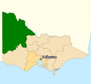
The Division of Mallee is an Australian Electoral Division in the state of Victoria. It is located in the far north-west of the state, adjoining the border with South Australia in the west, and the Murray River (which forms the border with New South Wales) in the north. At 70,694 square kilometres (27,295 sq mi), it is the largest Division in Victoria. It includes the centres of Mildura, Ouyen, Swan Hill, St Arnaud, Warracknabeal, Stawell and Horsham.
The Division was proclaimed at the redistribution of 11 May 1949, and was first contested at the 1949 election. It was named after the Mallee region of Victoria, in which the Division is located, which itself is named after the mallee variety of eucalyptus. Note that the Division also includes the Wimmera region of Victoria, which is why the title of the sitting member's newsletter is Wimmera Mallee News.
Mallee has always been a safe Country/The Nationals seat. It is currently the safest Coalition seat in federal parliament and also the safest seat in the entire parliament as of the 2010 election, with a 24-point swing required for Labor to win it. In the 2013 election, however, a Liberal Party candidate stood against the Country/National Party, making it a contest between Coalition parties.