
Surface area 2.84 km (1.10 sq mi) Surface elevation 26 m Shore length 13.97 km | Max. length 3 kilometres (1.9 mi) Max. depth 220 metres (720 ft) Area 2.84 km² | |
 | ||
Location Gulen Municipality,Sogn og Fjordane Max. width 1.6 kilometres (0.99 mi) Reference Norwegian Water Resources and Energy Directorate | ||
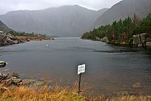
Dingevatn or Dingevatnet is the 18th deepest lake in Norway, reaching a maximum depth of 220 metres (720 ft). It is located in the municipality of Gulen in Sogn og Fjordane county. The 2.84-square-kilometre (1.10 sq mi) lake is located just east of the village of Dingja, about 1 kilometre (0.62 mi) southeast of the mouth of the Sognefjorden. The lake lies about 4 kilometres (2.5 mi) north of the municipal center of Eivindvik. The lake flows out into the small Dingjaelva river, which runs past the village of Dingja before emptying into the Sognesjøen strait.
Map of Dingevatn, 5966 Eivindvik, Norway
References
Dingevatn Wikipedia(Text) CC BY-SA