
Phone +49 6392 9150 | ||
 | ||
Hours Closed now Tuesday10AM–6PMWednesday10AM–6PMThursday10AM–6PMFriday10AM–6PMSaturday10AM–6PMSunday10AM–6PMMonday10AM–6PM Similar Palatinate Forest, Berwartstein Castle, Altdahn Castle, Jungfernsprung, Trifels Castle | ||
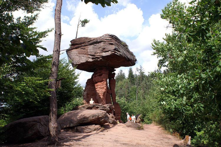
The Devil's Table (German: Teufelstisch) in Hinterweidenthal is a 14 metre high mushroom rock in the German part of the Wasgau region, the southern Palatine Forest in the state of Rhineland-Palatinate). Thanks to its location in the territory of the village of Kaltenbach - formerly part of Wilgartswiesen – it is often called the Kaltenbach Devil's Table (Kaltenbacher Teufelstisch), especially in old literary sources. It is larger and better known than the Devil's Table of Salzwoog, which is only 5 kilometres away to the southwest.
The Hinterweidenthal Devil's Table is one of the landscape symbols of the Palatinate and is also the subject of a local legend. In 1947 the rock was portrayed on a Rhineland-Palatinate postage stamp.
GeographyEdit
The Devil's Table stands a few hundred metres south of the B 10 road and west of Hinterweidenthal-Kaltenbach on a 312-metre-high ridge, which runs for over two kilometres from Etschberg in the southwest to the 324-metre-high Handschuh-Kopf in the northeast. The rock towers prominently over the surrounding woods. At night it is lit from the northern side, so that it can be seen from the B 10.
At the foot of the hill on which the Devil's Table stands, is a car park, an inn and the Devil's Table Adventure Park (Erlebnispark Teufelstisch).