
- right Qullpa Jawira - elevation 3,686 m (12,093 ft) Discharge 78 m³/s Mouth Lake Poopó Cities Desaguadero, Bolivia-Peru | - elevation 3,811 m (12,503 ft) Length 398 km Basin area 29,800 km² Source Lake Titicaca | |
 | ||
- left Ch'alla Jawira, Llallawa Jawira,
Jach'a Jawira (Caquiaviri),
Thujsa Jawira, Qala Jawira,
Jach'a Jawira (Ingavi) - location Desaguadero, Peru & Bolivia - location 50 kilometres (31 mi) S of Oruro, Bolivia | ||
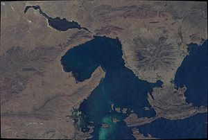
The Desaguadero River in Bolivia drains Lake Titicaca from the southern part of the river basin, flowing south and draining approximately five percent of the lake's flood waters into Lake Uru Uru and Lake Poopó. Its source in the north is very near the Peruvian border.
It is navigable only by small craft and supports indigenous communities such as the Uru Muratu community.
References
Desaguadero River (Bolivia) Wikipedia(Text) CC BY-SA