
 | ||
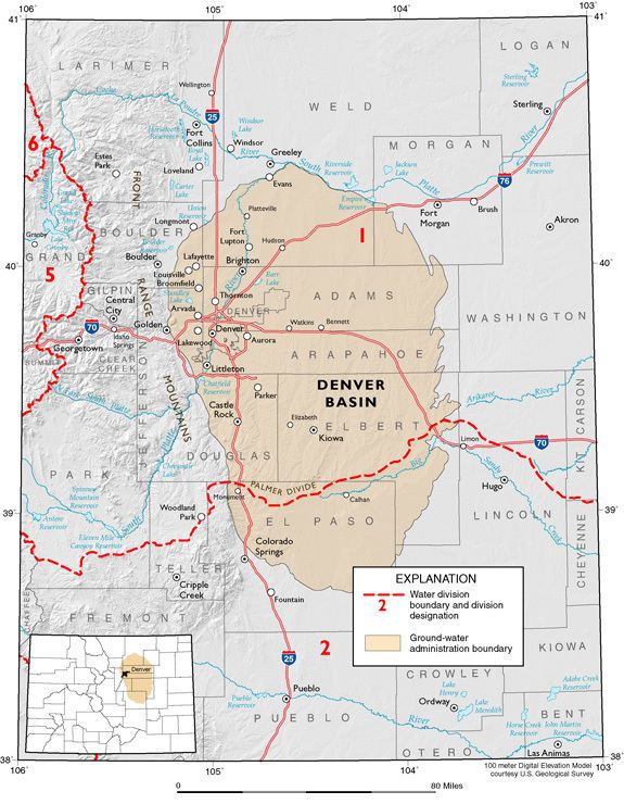
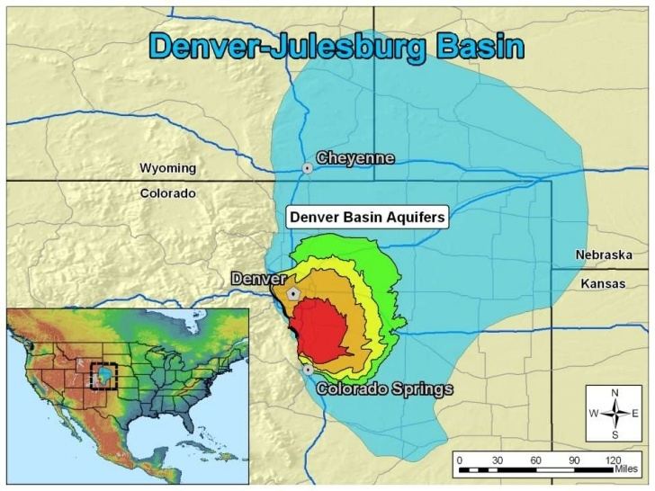
The Denver Basin, sometimes also called the Julesburg Basin, Denver-Julesburg Basin (after Julesburg, Colorado), or the D-J Basin, is a geologic structural basin centered in eastern Colorado in the United States, but extending into southeast Wyoming, western Nebraska, and western Kansas. It underlies the Denver-Aurora Metropolitan Area on the eastern side of the Rocky Mountains.
Geology
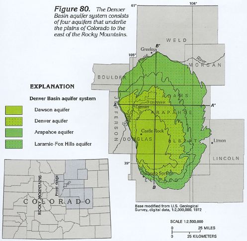
The basin consists of a large asymmetric syncline of Paleozoic, Mesozoic, and Cenozoic sedimentary rock layers, trending north to south along the east side of the Front Range from the vicinity of Pueblo northward into Wyoming. The basin is deepest near Denver, where it reaches a depth of approximately 13,000 ft (3900 m) below the surface. The basin is strongly asymmetric: the Dakota Sandstone outcrops in a "hog-back" ridge near Morrison a few miles west of Denver, reaches its maximum depth beneath Denver, then ascends very gradually to its eastern outcrop in central Kansas. The Dakota hogback exposes Dakota Sandstone overlying and protecting the Morrison Formation beneath and to the west. Between Golden and Morrison, the Dakota hogback is called Dinosaur Ridge and is the site of a dinosaur trackway and dinosaur fossils exposed in the outcrop that are part of a Colorado State Natural Area and Geological Points of Interest. The Lyons and Lykins formations outcrop in a smaller hogback. Farther west, the Fountain Formation outcrops as flatirons and forms the namesake of the Red Rocks Park and Amphitheatre. Here, against the eastern edge of the Rocky Mountain Front range, the Fountain Formation is in nonconformable contact with the Precambrian crystalline rock of the Idaho Springs Formation.
The basin started forming as early as 300 million years ago, during the Colorado orogeny that created the Ancestral Rockies. Rocks formed during this time include the Fountain Formation, which is most prominently visible at Red Rocks and the Boulder Flatirons.
The present basin was within the Cretaceous Interior Seaway, which deposited a thick Cretaceous section in the basin.
The basin was most likely further deepened in Paleogene time, between 66 and 45 million years ago, during the Laramide orogeny that created the modern Colorado Rockies. In particular, the uplifting of the Rockies in the Front Range caused the crust near Denver to buckle downward on the eastern side, deepening the basin. The basin later became filled with sediment eroded from the Rockies. The Front Range peaks rise approximately 22,000 ft (6600 m) from the floor of the basin under Denver.
The deep part of the basin near Denver became filled with Paleogene sandstone and conglomerate, a layer now called the Denver Formation. In the regions to the north and south of Denver, however, stream erosion removed the Paleogene layers, revealing the underlying Cretaceous Pierre Shale.