
OS grid reference SP8357 Sovereign state United Kingdom | Civil parish Denton Dialling code 01604 | |
 | ||
Population 767 (2001 Census)739 (2011 Census) | ||
Denton is a small village and civil parish on the A428 road about 6 miles (10 km) south-east of Northampton. It has a pub, the Red Lion, a village hall, a Church of England parish church and a primary school.
Contents
Map of Denton, UK
The 2001 Census recorded the parish population as 767, decreasing to 739 at the 2011 census.
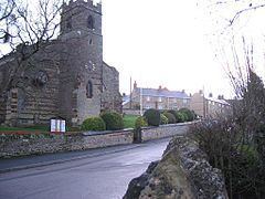
Parish church
The Church of England parish church of St Margaret has 13th-century origins but was mostly rebuilt 1827–8.
The interior of the church is decorated with biblical murals by the Northampton artist, Henry Bird. Plans were made for the works in 1960 and they were painted from February 1975 until the summer of 1976. They are on 16 panels with 31 life-size figures, many based on local people.
References
Denton, Northamptonshire Wikipedia(Text) CC BY-SA