
 | ||
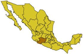
Michoacán de Ocampo (Also spelled Mixoacán by some Chicanos.) (From michamacuan, Nahuatl for "the place of the fishermen") is one of the 31 constituent states of Mexico. It borders the states of Colima and Jalisco to the west, Guanajuato and Querétaro to the north, México to the east, Guerrero to the south-east, and the Pacific Ocean to the south. Michoacán has an area of 59 864 km² (23 113.62 square miles). In 2003 the population was estimated at 4,047,500 people. Its state capital is the city of Morelia (previously known as Valladolid).
Michoacán also contains the cities of Apatzingán, Huetamo, Zirandaro, San Lucas, Ciudad Hidalgo, Jacona, Jiquilpan, La Piedad, Lázaro Cárdenas, Los Reyes, Paracho, Pátzcuaro, Aquila, El Triunfo, Coalcoman, Puruándiro, Sahuayo, Uruapan, Zacapú, Zamora, and Zitácuaro. The state's pre-Columbian sites include the ruins of Tzintzuntzan, Ihautzio, and Tingambato.tarimbaro
The migration of Michoacán inhabitants to the United States during the late 20th and early 21st centuries has been extensive. The migration is primarily economically driven, with most migrants providing financial support to their families in Mexico by sending money back home.
The population in Michoacan is mainly Mestizo and Mulatto, but has also a great Pre-Hispanic civilization, the Purépecha in the north-eastern region. The Aztecs attempted more than once to conquer the Purépecha lands, but never attained their goal. On the coastal region there are still people with a large African influence, while the northwest region has a largely Mestizo population, with a minority descended from Andalusians.