
Country Philippines Time zone PST (UTC+8) Area 189 km² Province Isabela | Barangays ZIP code 3326 Local time Monday 8:29 AM | |
 | ||
Region Cagayan Valley (Region II) District 1st District of Isabela Weather 25°C, Wind S at 3 km/h, 79% Humidity | ||
Delfin Albano is a 4th class municipality in the province of Isabela, Philippines. According to the 2015 census, it has a population of 26,614 people.
Contents
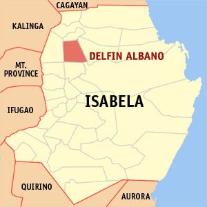
Map of Delfin Albano, Isabela, Philippines
The municipality was formerly known as Magsaysay. It was named after the former congressman, Delfin Albano.
History
In 1957, the barrios of San Antonio, San Juan, Ragan Sur, Ragan Norte, Ragan Almacen, San Jose (Bulo), San Patricio, Quibal, San Andres (Lattu), Calinawan Sur, Bayabo, Santor, Sto. Rosario, Andarayan, Aneg, San Isidro, Mawi, San Roque, Carmencita, Aga, Villa Pareda, Villaluz, San Pedro, Concepcion, San Macario and San Nicolas and the sitios of Turod, Paco, Calamagui and Kim-malabasa, were separated from the municipality of Tumauini to form the town of Magsaysay.
Geography
The Municipality of Delfin Albano is located at 38 kilometres (24 mi) north-west of Ilagan City, the capital city of the Province of Isabela. The town is bounded on the north by the municipality of Santo Tomas, on the east by the Cagayan River, on the west by the municipalities of Quezon and Mallig, and on the south by the municipality of Quirino and the Ilagan and the Mallig River.
Land Area and land use
The Municipality of Delfin Albano occupies a total land area of 19,000 hectares, which is further subdivided among the 29 barangays. The total land area contains varied land use, which were developed in response to population and economic growth of the total land area, to wit: agriculture (59.04%), built-up areas (2.74%), forest (4.74%), open grass lands (30.15), and road and water bodies (3.33%).
Barangays
Delfin Albano is politically subdivided into 29 barangays.