
Year first constructed 1914 Construction wooden tower Area 45 km² | Foundation concrete basement Height 8 metres (26 ft) Population 851 (2001) | |
 | ||
Tower shape square frustun tower with balcony and lantern Markings / pattern white tower, red lantern roof | ||
Deer Island is one of the Fundy Islands in the Bay of Fundy, Canada. It is at the entrance to Passamaquoddy Bay.
Map of Deer Isle, ME, USA
The island was first settled by colonists around 1770. Administratively it is in Charlotte County, New Brunswick, At 45 km2, it is the largest in the West Isles Parish (census division) which had a 2001 population of 851. It has three communities: Fairhaven, Leonardville, and Lords Cove. There is a primary school on the island, while older pupils attend Fundy High School on the mainland.
The economy is primarily fishing and aquaculture based although tourism is growing. The Old Sow, the largest tidal whirlpool in the western hemisphere can be viewed from Deer Island Point Park.
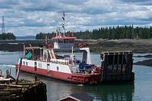
The major route is New Brunswick Route 772. The year round L'Etete to Deer Island Ferries run by the government, Deer Island Princess II and Abnaki II, connect Deer Island with L'Etete, New Brunswick on the mainland. During the summer, privately operated ferries, through East Coast Ferries Ltd, operate the Cummings Cove to Welshpool Ferry, Hopper II, to Campobello Island, and the Cummings Cove to Eastport Ferry, Fundy Trail II to Maine.