
 | ||
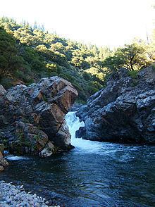
Deer Creek is a large stream in Northern California that flows through Tehama County, California. It is an eastside tributary of the Sacramento River, draining 134 square miles (350 km2). The creek flows roughly southwest for most of its 68.8-mile (110.7 km) length. Its headwaters are in Lassen National Forest at an elevation of 7,320 feet (2,230 m) on Butt Mountain in the Cascade Range, several miles west of Lake Almanor. The creek's upper reaches are through meadows and dense forests, then it flows through a steep rock canyon and into Sacramento Valley. About 11 miles (18 km) after entering the valley, it joins the Sacramento River at an elevation of only 180 feet (55 m), about 7 miles (11 km) south-southeast of the small city of Tehama, California.
Map of Deer Creek, California, USA
The creek has four diversions, all occur after the stream flows into the Sacramento Valley. Three use diversion dams and one uses a ditch. There are no storage dams on the creek. Except for the diversions, Deer Creek is still relatively natural. This is probably because the upper two-thirds of the creek flow through protected land in the Lassen National Forest.
Deer Creek is also an excellent fishing location. It is one of a decreasing number of streams in California that still provides habitat for the native trout and migrating salmon.