Im a travel junky who loves to gain
knowledge coz u know knowledge is power
Dead Man's Curve
Updated on
Edit
Like
Comment
Share
Sign in
Dead man s curve jan and dean with lyrics
Dead man's curve is a nickname for a curve in a roadway that has claimed lives because of numerous traffic accidents. The term is in common use in the United States.
Interstate 20 east of the Birmingham International Airport, at its junction with Interstate 59; engineers built a curve into the highway to avoid a cemetery.
Interstate 59 about 4 miles north of Gadsden. The S-shaped curve was built to avoid running into a steep mountain.
A sharp turn in a series of sharp bends on Kali Oka Road, in Saraland, just south of a Crybaby Bridge.
Some say it is a nearly 90° right turn traveling west on Sunset Boulevard just past North Whittier Drive.
Others say it is located near the Bel Air estates north of UCLA's Drake Stadium going eastbound (not westbound as in the song). While an accident involving voice actor Mel Blanc prompted safety improvement, the curve remains today.
Others remember the location as the curve at Evans Road going westbound (as in the song), a decreasing radius blind turn to the left with a downhill entry. Maximum speed in the first half of the turn is too fast for the last half of the turn, making it all too easy to lose control, run off the road and crash.
A temporary S-shape curve on the eastern span of the San Francisco–Oakland Bay Bridge (part of Interstate 80). After its installation on September 8, 2009, to divert traffic as part of a replacement project, 43 accidents took place, including one fatal crash.
A sharp turn in the shape of a "U" on SR 76 in San Diego County, near Red Gate Road. The curve has claimed the lives of many motorcyclists.
Colorado
A sharp turn on eastbound Interstate 70 near Morrison that is preceded by a 7-mile (11 km) stretch of a 6.5% grade downslope, which has been the site of numerous fatal runaway truck accidents.
A high-banked turn on eastbound US 50 just west of Cañon City that is preceded by an 8-mile (13 km) stretch of downslope, which has caused several vehicles to go over the banked edge and wreck.
Hawaii
A sharp turn at the end of Kapaa Quarry Road, which is a dimly lit utility road in Kailua, Honolulu County, that has claimed eight fatalities and is considered one of Oahu's haunted roads.
Illinois
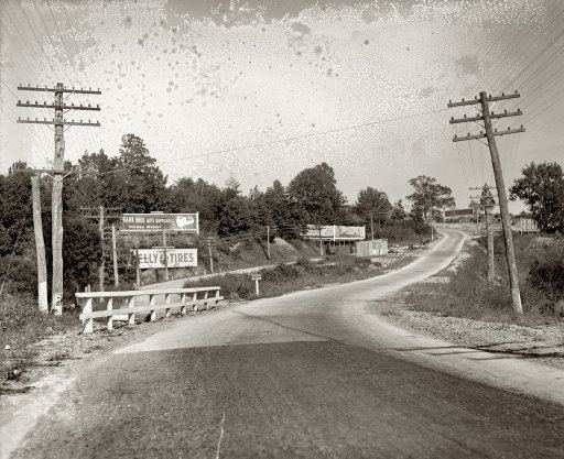
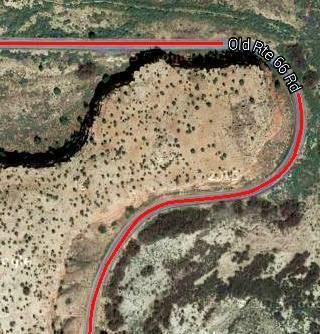
In Towanda, Illinois, an almost 90° Dead Man's Curve on the original Old U.S. Route 66 was the site of many accidents; a number of which ended in fatalities. The roadbed was eventually turned into a park and walking trail.
Indiana
In Indianapolis, a curve on Interstate 70 westbound at mile marker 83.1 When opened, it had a negative camber on the right shoulder, and several truckers lost control and hit the a bridge abutment, losing their lives. The stretch was closed, re-engineered with a positive bank and with rain slots along the boundary and was reopened with a 40 miles per hour (64 km/h) speed limit.
Kentucky
A treacherous stretch of Interstate 75 in Northern Kentucky, originally known as "Death Hill" and now known as "Cut-in-the-Hill."
Louisiana
In northern Bossier Parish, a sharp curve on Louisiana 157 (Hickory Drive), just inside the city limits of Plain Dealing, south of the town cemetery.
Maryland
Interstate 83 (Jones Falls Expressway) in Baltimore.
Michigan
In Marquette Township, Marquette County, Dead Man's Curve referred to a curve on County Road 492 (previously a part of M-15), where the first state highway centerline in the United States was painted. Geographical coordinates: 46.5318°N 87.474°W / 46.5318; -87.474
In Milford, MI, Oakland County (42°33'37.4"N 83°35'50.0"W)
Missouri
Sharp turn on Missouri State Route 34 just east of Garwood, in Reynolds County.
Missouri letter Hwy A in Franklin County between Washington and Krakow (38.520580°N 91.037139°W / 38.520580; -91.037139)
New Mexico
Near Mesita, a 180º bend in the road to the left on Historic U.S. Route 66 nicknamed "Dead Man's Curve"
Between Albuquerque and Tijeras, State Road 333 (previously known as U.S. Route 66) makes a sudden curve near the I-40 overpass. This stretch of highway has earned its name because of the rocky cliffs on the south side of the highway, and frequent deer traffic contributes to its hazardousness
New York
A 90º turn on New York State Route 17 in Binghamton, near the junction with Interstate 81 and Interstate 88, which also goes by the name Kamikaze Curve. The tight curve, which hugs Prospect Mountain along the Chenango River, is slated for improvements as part of NY 17's upgrade to Interstate 86.
Union Square in Manhattan had a long history of traffic congestion extending back to the 1890s, when trolley lines were first installed. Two parallel trolley lines made a double curve at the southwest corner of Broadway and Fourteenth Street. In spite of traffic wardens on duty, the trolleys regularly struck pedestrians crossing the tracks in the busy shopping district around the park.
By 1930, the Fourteenth Street Association, a retail business association headed by its president, H. Prescott Beach, had successfully lobbied the New York transit authority to remove the above-ground rails, and move routes underground.
Ohio
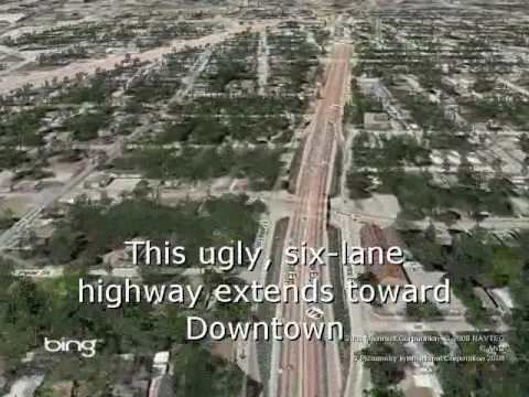
The nearly 90º turn on Interstate 90 near downtown Cleveland, officially called the "Innerbelt Curve", at the point where the Cleveland Memorial Shoreway connects to the Innerbelt Freeway at a modified trumpet interchange just south of Burke Lakefront Airport. The advisory speed is 35 miles per hour (56 km/h), although the maximum speed limit is 50 miles per hour (80 km/h), as on adjacent sections of the Shoreway and Innerbelt. Location: 41.5173°N 81.6754°W / 41.5173; -81.6754
Dead Man's Curve was constructed as part of the Innerbelt project in 1959. At the time, Interstate 90 had been planned to continue westward on the Shoreway, connecting with its current location via the never-built Parma Freeway. It soon became apparent that the curve was too sharp for travel at typical Interstate speeds, and in 1965, the state lowered the speed limit from 50 mph (80 km/h) to 35 mph (56 km/h). Four years later, authorities completed the first set of safety retrofits, which included banking the curve and installing rumble strips and large signs.According to the Ohio Department of Transportation (ODOT), the crash rate on the Innerbelt (which includes Dead Man's Curve) is two to three times the regional average for urban freeways, despite the reduced speed limits on the roadway. The department has investigated ways of enhancing safety on the stretch, including a complete realignment of the roadway to reduce the degree of the curve. As of 2014 the proposed configuration of the curve as presented in the ODOT Innerbelt Plan is still planned to be built but not until the mid-2020s. According to a 2013 ODOT count, 64,720 vehicles travel on the curve every day.
A sharp bend in U.S. Route 50 (Columbia Parkway) east of Cincinnati
Sharp turn 5 on Interstate 75 just north of downtown Dayton
Oregon
On the Mount Hood Scenic Byway between Zigzag and Government Camp
Pennsylvania
The northern terminus of Interstate 476 in Clarks Summit is a 180° turn, with an advisory speed limit of 20 miles per hour (32 km/h), created in order to access a toll plaza before the interchange with Interstate 81.
On U.S. Route 22 in Easton, there are several dangerous sharp turns that go past a graveyard. (This is most commonly known as "Cemetery Curve" for that reason.) Streetlights were installed to help cut down on nighttime crashes; the lightposts are themselves frequent victims of collisions.
South Carolina
A dangerous curve on South Carolina Highway 9 about 10 miles west of Chester, South Carolina, is responsible for several fatal crashes. Deceased drivers' families and Chester County officials have been lobbying the South Carolina Department of Transportation to improve road safety.
Texas
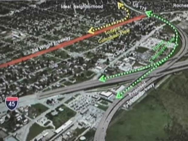
A sharp, sudden turn on U.S. Route 175 (C. F. Hawn Freeway) at the interchange with SH 310 southeast of downtown Dallas. After a fatal truck accident in 2008, the state installed additional beacons and also flashing chevrons to further draw motorists' attention to the hazard. As of 2010, the department of highways is studying plans to eliminate this curve by extending the C. F. Hawn Freeway westward to Interstate 45.
Zoomweg
A sharp, sudden turn on A59 at the interchange with A4 south of Helwijk.
Zoomland
As well a sharp, sudden turn on A58 at the interchange with A4 east of Bergen Op Zoom.