
 | ||
Similar Jamaica Bay, Gateway National Recreatio, Fort Tilden, Marine Parkway–Gil Hodges, Jacob Riis Park | ||
Dead Horse Bay is a small water body off Barren Island between the Gerritsen Inlet and Rockaway Inlet in the New York City borough of Brooklyn.
Map of Dead Horse Bay, Brooklyn, NY 11234, USA
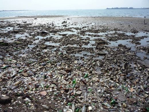
From the nineteenth century to the twentieth century the area has been used in a variety of ways, including manufacturing fertilizer from the remains of dead animals, producing fish oil from the menhaden caught in the bay, and more recently a landfill for the disposal of New York City’s garbage. A millstone used to grind horse bones can still be found along the Millstone trail. In 1926, much of the salt marsh surrounding Dead Horse Bay and the rest of Barren Island were pumped with sand from Jamaica Bay. This raised the land to 16 feet above the high tide mark and connected the islands to each other, and the mainland of Brooklyn, in order to create Floyd Bennett Field as New York City's first municipal airport. The entire area, including the historic airfield, is now managed by the National Park Service as part of the Jamaica Bay Unit of the Gateway National Recreation Area.
Today, school groups are taken to Dead Horse Bay on a regular basis to walk the Millstone trail, seine for a variety of fishes, and learn about the natural and cultural history of the area. Its shores are also a popular sport fishing spot, and home to a marina operating in Deep Creek as a National Park Service concession. Today one can find a large array of glass bottles and pieces of broken glass on the beach, along with old shoes and construction materials, many from the landfill which is now leaking. It is a popular place to collect strange decorative materials for artists and crafters.