
Country United States County Chippewa FIPS code 26-21780 Elevation 183 m Population 327 (2013) Area code 906 | State Michigan Time zone Eastern (EST) (UTC-5) GNIS feature ID 0624391 Zip code 49725 Local time Saturday 4:08 PM | |
 | ||
Weather -7°C, Wind SE at 13 km/h, 59% Humidity Area 21.7 km² (9.194 km² Land / 12.51 km² Water) | ||
De Tour Village is a village in Chippewa County in the U.S. state of Michigan. The population was 325 at the 2010 census.
Contents
Map of De Tour Village, MI 49725, USA
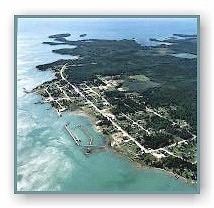
The village is at the extreme eastern tip of the Upper Peninsula of Michigan, in Detour Township, at the turning point for the shipping channel connecting the St. Mary's River with Lake Huron and the Straits of Mackinac. Drummond Island, one of the largest islands in the St. Mary's River, is only one mile across the river from De Tour. The De Tour Reef Light is nearby.
History
The place was originally an Ojibwe settlement. It was connected with the fur trade and over time it came to have a large Metis population. Over time the Metis inhabitants were redefined as being French-Canadian.
The area was organized in 1850 as Warren Township, named after Ebenezer Warren, the first postmaster of the township. The settlement was called Warrenville on an 1848 map. The name was changed to Detour in 1856 when a new postmaster, Henry A. Williams, assumed office. It incorporated as a village in 1899. The spelling was changed to "De Tour" in 1953 and the post office was renamed "De Tour Village" in 1961.
M-134 runs through the village, connecting with I-75 43 miles (69 km) to the west and with M-129 25 miles (40 km) to the west, which runs north 37 miles (60 km) to Sault Ste. Marie. M-134 also continues east to Drummond Island via the Drummond Island Ferry.
Geography
According to the United States Census Bureau, the village has a total area of 8.38 square miles (21.70 km2), of which 3.55 square miles (9.19 km2) is land and 4.83 square miles (12.51 km2) is water.
Major highways
Demographics
As of 2000 the median income for a household in the village was $31,250, and the median income for a family was $45,104. Males had a median income of $27,188 versus $33,125 for females. The per capita income for the village was $19,967. About 6.5% of families and 10.4% of the population were below the poverty line, including 32.6% of those under age 18 and 5.7% of those age 65 or over.
2010 census
As of the census of 2010, there were 325 people, 166 households, and 96 families residing in the village. The population density was 91.5 inhabitants per square mile (35.3/km2). There were 307 housing units at an average density of 86.5 per square mile (33.4/km2). The racial makeup of the village was 82.8% White, 12.9% Native American, and 4.3% from two or more races. Hispanic or Latino of any race were 0.6% of the population.
There were 166 households of which 16.3% had children under the age of 18 living with them, 52.4% were married couples living together, 1.8% had a female householder with no husband present, 3.6% had a male householder with no wife present, and 42.2% were non-families. 38.6% of all households were made up of individuals and 20.5% had someone living alone who was 65 years of age or older. The average household size was 1.96 and the average family size was 2.56.
The median age in the village was 57.6 years. 15.4% of residents were under the age of 18; 2.8% were between the ages of 18 and 24; 15.4% were from 25 to 44; 28.3% were from 45 to 64; and 38.2% were 65 years of age or older. The gender makeup of the village was 49.5% male and 50.5% female.