
FIPS code 55-19850 Elevation 199 m Local time Saturday 3:01 PM | Time zone Central (CST) (UTC-6) GNIS feature ID 1563761 Population 286 (2013) Area code 608 | |
 | ||
Weather 6°C, Wind E at 26 km/h, 57% Humidity Area 3.471 km² (3.237 km² Land / 23 ha Water) | ||
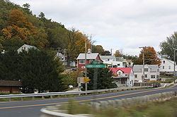
De Soto is a village mostly in Crawford County but also in Vernon County in Wisconsin. The population was 287 at the 2010 census. Of this, 179 were in living in Vernon County, and 108 were living in Crawford County. the downtown and business area is in Crawford County.
Contents
Map of De Soto, WI 54624, USA
History
De Soto was named after Hernando De Soto the explorer who discovered the Mississippi. It was originally settled by Yankee settlers from New England. These were people descended from the English Puritans who settled New England in the colonial period. They were part of a migration of Yankee settlers from New England who moved west into the wilds of what was then the wilds of the Northwest Territory in the 1830s. The opening of the Erie Canal made this journey much easier, and the end of the Black Hawk War made the region much safer. These two events saw the already steady trickle of New Englanders turn into a heavy stream of migration. The founding of De Soto, Wisconsin was one small part of that migration.
Geography
De Soto is located at 43°25′37″N 91°11′49″W (43.426905, -91.196841).
According to the United States Census Bureau, the village has a total area of 1.34 square miles (3.47 km2), of which, 1.25 square miles (3.24 km2) of it is land and 0.09 square miles (0.23 km2) is water.
2010 census
As of the census of 2010, there were 287 people, 129 households, and 80 families residing in the village. The population density was 229.6 inhabitants per square mile (88.6/km2). There were 176 housing units at an average density of 140.8 per square mile (54.4/km2). The racial makeup of the village was 99.7% White and 0.3% from two or more races.
There were 129 households of which 31.0% had children under the age of 18 living with them, 48.8% were married couples living together, 10.1% had a female householder with no husband present, 3.1% had a male householder with no wife present, and 38.0% were non-families. 31.8% of all households were made up of individuals and 15.5% had someone living alone who was 65 years of age or older. The average household size was 2.22 and the average family size was 2.83.
The median age in the village was 44.1 years. 23.3% of residents were under the age of 18; 3.9% were between the ages of 18 and 24; 24.5% were from 25 to 44; 31.8% were from 45 to 64; and 16.7% were 65 years of age or older. The gender makeup of the village was 51.2% male and 48.8% female.
2000 census
As of the census of 2000, there were 366 people, 151 households, and 104 families residing in the village. The population density was 283.6 people per square mile (109.5/km²). There were 191 housing units at an average density of 148.0 per square mile (57.2/km²). The racial makeup of the village was 95.08% White, 1.64% African American, 0.55% Asian, 0.27% from other races, and 2.46% from two or more races. Hispanic or Latino of any race were 1.64% of the population.
There were 151 households out of which 26.5% had children under the age of 18 living with them, 61.6% were married couples living together, 4.0% had a female householder with no husband present, and 30.5% were non-families. 25.2% of all households were made up of individuals and 13.2% had someone living alone who was 65 years of age or older. The average household size was 2.42 and the average family size was 2.93.
In the village, the population was spread out with 22.7% under the age of 18, 4.4% from 18 to 24, 23.5% from 25 to 44, 32.2% from 45 to 64, and 17.2% who were 65 years of age or older. The median age was 44 years. For every 100 females there were 89.6 males. For every 100 females age 18 and over, there were 88.7 males.
The median income for a household in the village was $33,036, and the median income for a family was $40,000. Males had a median income of $30,313 versus $16,250 for females. The per capita income for the village was $18,042. About 7.4% of families and 7.4% of the population were below the poverty line, including 13.7% of those under age 18 and 7.0% of those age 65 or over.
Education
The De Soto Area Schools serves De Soto, Wisconsin. [1]