
Country India Region Marathwada Time zone IST (UTC+5:30) | State Maharashtra District Aurangabad Phone 0240 234 3169 | |
 | ||
Demonym(s) Daulatabadi, Devagirikar Address MH SH 22, Daulatabad, Maharashtra 431002 Hours Open today · 8AM–6PMSaturday8AM–6PMSunday8AM–6PMMonday8AM–6PMTuesday8AM–6PMWednesday8AM–6PMThursday8AM–6PMFriday8AM–6PM Similar Bibi Ka Maqbara, Ajanta Caves, Panchakki, Grishneshwar, Aurangabad Caves | ||
A short trip to daulatabad
Daulatabad also known as Devagiri, is a town which includes the Devagiri-Daulatabad fort It carries the distinction of remaining undefeated in battle. It is a 14th-century fort city in Maharashtra state of India, about 16 kilometres (9.9 mi) northwest of Aurangabad. The place was originally named Devagiri when it was an important uplands city along caravan routes (ca. sixth century AD), but the intervening centuries have reduced it to a village. However it is also considered to be one of the seven wonders of Maharashtra and a developing tourist spot.
Contents
- A short trip to daulatabad
- Mythological origin
- Fort of Daulatabad
- The City
- History
- Monuments
- Road Transport
- Rail Transport
- References
The historical triangular fort of Daulatabad was built by first Yadav king Bhilan in 1187.
Starting 1327, it famously remained the capital of Tughlaq dynasty, under Muhammad bin Tughluq (r. 1325-1351), who also changed its name, and forcibily moved the entire population of Delhi for two years before it was abandoned for lack of water and Tughluq was constantly known to shift the capital from Delhi to Daulatabad and Daulatabad to Delhi.
There is a belief that Devagiri was built in 1203 AD by a Dhangar or herdsman who acquired vast wealth by his good fortune. He had a brother who was a shepherd named 'Raja Ram' and in correlation with it he assumed the rank of a Raja (King).
Mythological origin
Lord Shiva is believed to have been stayed on the hills surrounding this region. Hence the fort was originally known as Devagiri literally (Hills of Gods).
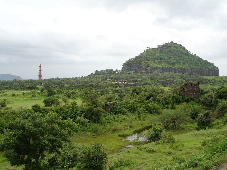
Fort of Daulatabad
The area of the city includes the hill-fortress of Devagiri (Marathi) (sometimes Latinised to Deogiri). It stands on a conical hill, about 200 meters high. Much of the lower slopes of the hill has been cut away by Yadava dynasty rulers to leave 50 meter vertical sides to improve defenses. The fort is a place of extraordinary strength. The only means of access to the summit is by a narrow bridge, with passage for not more than two people abreast, and a long gallery, excavated in the rock, which has for the most part a very gradual upward slope.
About midway along this gallery, the access gallery has steep stairs, the top of which is covered by a grating destined in time of war to form the hearth of a huge fire kept burning by the garrison above. At the summit, and at intervals on the slope, are specimens of massive old cannon facing out over the surrounding countryside. Also at the mid way, there is a cave entrance meant to confuse the enemies.
The City
Devagiri (190 57’ N; 750 15’ E) is located at a distance of 15 km northwest of Aurangabad, the district headquarters and midway to Ellora group of caves. The original widespread capital city is now mostly unoccupied and has been reduced to a village. Much of its survival depends on the tourists to the old city and the adjacent fort.
History
The site had been occupied since at least 100 BCE, and now has remains of Buddhist temples similar to those at Ajanta and Ellora.
The city is said to have been founded c. 1187 by Bhillama V, a prince who renounced his allegiance to the Chalukyas and established the power of the Yadava dynasty in the west.
Most of the fortification has been constructed under the Bahmanis and the Nizam Shahs of Ahmadnagar. The Mughal Governor of the Deccan under Shah Jahan, captured the fortress in 1632 and imprisoned the Nizam Shahi prince Husain Shah.
Monuments
The outer wall, 2.75 miles (4.43 km) in circumference, once enclosed the ancient city of Devagiri and between this and the base of the upper fort are three lines of defences.
Along with the fortifications, Devagiri contains several notable monuments, of which the chief are the Chand Minar and the Chini Mahal. The Chand Minar is a tower 210 ft (64 m). high and 70 ft (21 m). in circumference at the base, and was originally covered with beautiful Persian glazed tiles. It was erected in 1445 by Ala-ud-din Bahmani to commemorate his capture of the fort. The Chini Mahal (literally: China Palace), is the ruin of a building once of great beauty. In it Abul Hasan Tana Shah, the last of the Qutb Shahi kings of Golconda, was imprisoned by Aurangzeb in 1687.
Road Transport
Devagiri is in the outskirts of Aurangabad, and is on the Aurangabad - Ellora road (National Highway 2003). Aurangabad is well connected by road and 20 km away from Devagiri.
Rail Transport
Daulatabad railway station is located on the Manmad-Purna section of Central Railways and also on the Kachiguda-Manmad section of the Nanded Division of South Central Railway. Until reorganisation in 2012 ,it was a part of the Hyderabad Division Aurangabad is a major station near to Devagiri. The Devagiri Express regularly operates between Mumbai and Secunderabad via Aurangabad, Maharashtra