
Country India Headquarters Ahwa Vehicle registration GJ | State Gujarat Time zone IST (UTC+5:30) Website gujaratindia.com | |
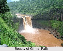 | ||
Points of interest Gira Falls, Mahal, Lake Garden, Saputara Museum, Girmal Waterfall | ||
Dang ( Listen ), also known as The Dangs, is a district in the state of Gujarat in India. The administrative headquarters of the district are located in Ahwa. The Dangs have an area of 1,764 km² and a population of 226,769 (as of 2011).
Contents
Map of Dang, Gujarat
As of 2011 it is the least populous district of Gujarat (out of 33).
As per the Planning Commission, Dangs is the most economically distressed district out of 640 districts in India. Saputara and Waghai are important places in this district.
Tehsil
- Waghai
- Ahwa
- Subir
History
Before Independence several wars were fought between the five tribal kings of Dang and the British Raj. According to the history of Dang, the biggest war to took place at Lashkaria Amba, in when the kings of all the five states joined together to protect Dang from British rule. The British were beaten and agreed to a compromise.
As per the treaty signed in 1842 the British were allowed to use the forests and their natural products against which they had to pay around 3,000 silver coins to the five kings. Currently the kings receive a monthly political pension by the Government of India, which is the main source of their income. This payment is continued even though all privy purses for the Princely states of India were stopped in 1970 since the agreement was between then monarchy of Dangs and the British.
At the end of each fiscal year, the kings gather in Ahwa for a traditional royal ceremony, in their richly decorated buggies and bands with tribal dancers, to receive the payment as per the agreement of 1842. In ancient Indian Scriptures Dang is known as Dand Aranyaka, meaning Bamboo Forest.
The five kingdoms are Daher, Linga, Gadvi, Vasurna and Pimpri.
Demographics
According to the 2011 census Dang district has a population of 226,769, roughly equal to the nation of Vanuatu. This gives it a ranking of 587th in India (out of a total of 640). The district has a population density of 129 inhabitants per square kilometre (330/sq mi) . Its population growth rate over the decade 2001-2011 was 21.44%. The Dangs has a sex ratio of 1007 females for every 1000 males, and a literacy rate of 76.8%.
Economy
In 2006 the Ministry of Panchayati Raj named Dang District as an economically distressed district, one of 250 out of a total of 640 districts. It is one of the six districts in Gujarat currently receiving funds from the Backward Regions Grant Fund Programme (BRGF).
Forest of the Dangs
Dang District has part of a forest that includes Purna Wildlife Sanctuary, which is shared between the districts of Dang and Tapi in Gujarat and Nandurbar District in Maharashtra, and Vansda National Park in Navsari District, which shares a continuous tract of forest with Valsad District. The evergreen forest in this region is in the range of the rusty-spotted cat. Also, though the Bengal tiger is reportedly extinct in Gujarat, the region where southeastern Gujarat meets Maharashtra and Madhya Pradesh nevertheless has tigers, making this forest a potential habitat of the tiger.