
Population 17,985 (2001) Civil parish Dalserf Sovereign state United Kingdom Local time Thursday 5:14 AM | OS grid reference NS7950 Post town LARKHALL Dialling code 01698 | |
 | ||
Weather 7°C, Wind W at 31 km/h, 86% Humidity Lieutenancy areas South Lanarkshire, Lanarkshire | ||
Dalserf is a small village and civil parish in South Lanarkshire, Scotland. It lies on the River Clyde, 2 miles (3 km) east of Larkhall and 7 miles (11 km) south east of Hamilton. As of 2006, the village itself has a population of 52, while the wider parish (which includes Ashgill, Larkhall, Netherburn, Rosebank and Shawsburn) has a population of 17,985.
Map of Dalserf, Larkhall, UK
The name of the village comes from the Gaelic dail, meaning field, and Serf, the name of a 6th-century saint who dwelt here. Of old, it was also known as Machan or Machanshire, from the Gaelic Maghan meaning small plain.
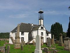
The village kirk, built in 1655, is dedicated to Saint Serf, and may be built on the site of an early church founded by him. The church dates from The Killing Time, when the rebel Covenanters were persecuted for their faith, and was a centre of Covenanter activity. John McMillan, reformist preacher and first minister of the Reformed Presbyterian Church, is buried in the kirkyard. The kirk is Category A listed.
A ferry once operated across the Clyde at Dalserf, although this has long since been superseded by the nearby Garrion Bridge. Dalserf railway station once served the village.