
Country of origin France Type Civilian First launch 1990 (1990) | Operator(s) CNES Status Operational | |
 | ||
Doppler Orbitography and Radiopositioning Integrated by Satellite or, in French, Détermination d'Orbite et Radiopositionnement Intégré par Satellite (in both case yielding the acronym DORIS) is a French satellite system used for the determination of satellite orbits (e.g. TOPEX/Poseidon) and for positioning.
Contents
Principle
Ground-based radio beacons emit a signal which is picked up by receiving satellites. This is in reverse configuration to other GNSS, in which the transmitters are space-borne and receivers are in majority near the surface of the Earth. A frequency shift of the signal occurs that is caused by the movement of the satellite (Doppler effect). From this observation satellite orbits, ground positions, as well as other parameters can be derived.
Organization
DORIS is a French system which was initiated and is maintained by the French Space Agency (CNES). It is operated from Toulouse.
Ground segment
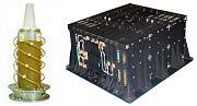
The ground segment includes about 50-60 ground stations, equally distributed over the earth and ensure a good coverage for orbit determination. For the installation of a beacon only electricity is required because the station only emits a signal but does not receive any information. DORIS beacons transmit to the satellites on two UHF frequencies, 401.25 MHz and 2036.25 MHz.
Space segment
The best known satellites equipped with DORIS receivers are the altimetry satellites TOPEX/Poseidon, Jason 1 and Jason 2. They are used to observe the ocean surface as well as currents or wave heights. DORIS contributes to their orbit accuracy of about 2 cm.
Other DORIS satellites are the Envisat, SPOT, HY-2A and CryoSat-2 satellites.
Positioning
Apart from orbit determination, the DORIS observations are used for positioning of ground stations. The accuracy is a bit lower than with GPS, but it still contributes to the International Terrestrial Reference Frame (ITRF).