
Admin. region Stuttgart Elevation 543 m (1,781 ft) Area 5.37 km² Local time Wednesday 10:55 PM Dialling code 07164 | Time zone CET/CEST (UTC+1/+2) Population 2,112 (31 Dec 2008) Postal code 73105 Administrative region Stuttgart | |
 | ||
Weather 8°C, Wind SW at 26 km/h, 91% Humidity | ||
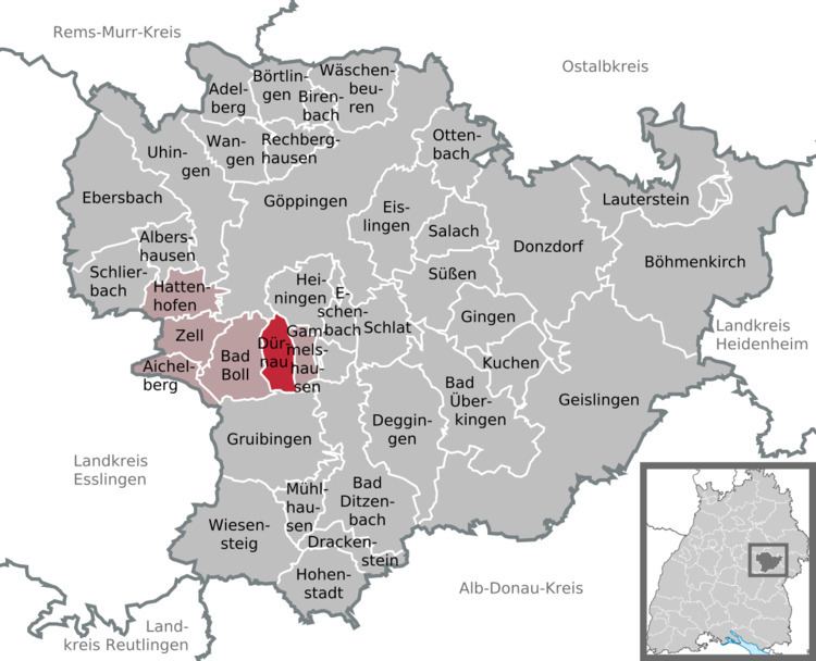
Dürnau is a municipality in the district of Göppingen in Baden-Württemberg in southern Germany.
Contents
- Map of DC3BCrnau Germany
- Geographical location
- Neighboring communities
- Municipality arrangement
- History
- Religions
- Politics
- Mayor
- Council
- Crest
- Educational institutions
- Leisure and sports facilities
- Transportation
- References
Map of D%C3%BCrnau, Germany
Geographical location
Dürnau is on the edge of the Swabian Jura, about ten kilometers south of the county town Göppingen. The highest point is in the south on the border to the municipality of Gruibingen between Köpfle and Kornberg. The lowest point is north of the border to the municipality Heiningen.
Neighboring communities
The municipality borders in the north Göppingen and Heiningen, in the east Gammelshausen, in the south Gruibingen and in the west Bad Boll.
Municipality arrangement
The municipality Dürnau includes the village and the houses Ölmühle and Wilhelmshöhe.
History
The origin of the name is not entirely clear. Presumably, the name derives from a medieval watchtower, which stood on the territory of the present municipality. The place was first time mentioned as "Durnon" in 1275 in the liber decimatonis.
The low noble family Dürner of Dürnau was from the 13th to the 15th century probably as ministerials in the service of the Earl of Aichelberg. 1339 Dürnau became part of Württemberg. 1479 Ulrich, Duke of Württemberg sold the place to the gentlemen of Zillenhardt. After the extinction of the last Lord of Zillenhrdt in 1623 the village fell to the lords of Degenfeld. 1684 the place was sold to the Electorate of Bavaria.
Because of the German mediatization and the Mediatisation Dürnau 1806 became again part of Württemberg and came to Oberamt Göppingen. With the municipal reform 1938 the district came part of Göppingen.
Religions
Since the Reformation Dürnau is Protestant. Only since 1963, there is again a Roman Catholic church, which belongs to the parish of Bad Boll.
Politics
Since 1970 Dürnau belongs to the administration unit area Bad Boll.
Mayor
The mayor is since 1986 Friedrich Buchmaier.
Council
The Dürnau council has 10 members. The council consists of the elected honorary councilors and the mayor as chairman. The mayor is entitled to vote in the municipal council.
Crest
The blazon of the municipal coat of arms of Dürnau is: Argent, a black hunting horn with golden fetters. The coat of arms can be seen from the former local aristocracy of men of Dürnau, and was adopted in 1923. The derived flag colors black and white were awarded by the Ministry of the Interior on 18 February 1959.
Educational institutions
Dürnau has a common primary school and a common children's house with Gammelshausen.
Leisure and sports facilities
Dürnau has two sports fields, two tennis courts, a basketball court and a hard court. A youth house for young people is in Dürnau. There is also the Kornberg hall, which has a stage and thus can be used for cultural events. In the basement of the Kornberg hall is a gym and a teaching pool, which is also open to individuals. The hall of the Protestant church is also an ideal setting for smaller events.
Transportation
Dürnau is reachable by a road to Gammelshausen and Bad Boll. With the municipality Heiningen Dürnau is connected via a dirt road, which is however not released for public transport for transit. The connection point Aichelberg the Bundesautobahn 8 is located approximately 7 km away. Dürnau was also a halt of the Voralbbahn, which has ceased operation till 1989. Since then Dürnau is connected only through a bus line, for instance with the county town Göppingen.