
Formed February 9, 2006 Fatalities None reported Affected area Tonga | Dissipated February 22, 2006 Areas affected Tonga | |
 | ||
Highest winds 10-minute sustained: 130 km/h (80 mph)
1-minute sustained: 140 km/h (85 mph) Lowest pressure 965 hPa (mbar); 28.5 inHg Date 9 February 2006 – 22 February 2006 Similar Cyclone Tam, Cyclone Larry, Cyclone Urmil | ||
Severe Tropical Cyclone Vaianu (RSMC Nadi designation: 12F, JTWC designation: 11P) was the fourth named tropical cyclone of the 2005–06 South Pacific cyclone season. The system formed on February 11, and moved generally towards the south throughout its life. Vaianu ultimately peaked with winds corresponding to Category 1 status on the Saffir-Simpson Hurricane Scale, and passed between Fiji and Tonga. Moving into cooler waters, the storm dissipated on February 16. Although the cyclone avoided land for the most part, it caused heavy rainfall and gusty winds in portions of Tonga. Flooding hit the capital city of Nuku'alofa, and on some islands, the storm destroyed crops.
Contents
Meteorological history
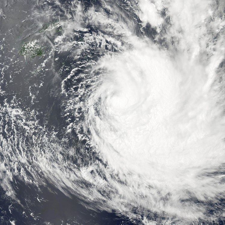
Late on February 9, the Regional Specialized Meteorological Centre (RSMC) in Nadi, Fiji reported that Tropical Depression 12F had developed within a convergence zone which was located about 140 km (87 mi) to the northeast of Vanua Levu. The depression tracked southeastward, although further development was initially inhibited by wind shear. During the next day, the depression turned towards the southeast and moved into a more favorable environment for intensification. It was then designated as Tropical Depression 11P at 1800 UTC by the Joint Typhoon Warning Center (JTWC). On February 11, the system significantly organized, and at 1200 UTC that day, RSMC Nadi reported that the depression had intensified into a Category 1 tropical cyclone on the Australian tropical cyclone intensity scale; it was assigned the name Vaianu.
At the time of being upgraded to a cyclone, Vaianu was situated about 190 km (120 mi) to the northwest of Vavaʻu, a Tonga island chain. The storm turned southwestward under the steering currents of a ridge to the southeast. The JTWC recognized the system as a tropical storm on February 12, and upgraded it into a tropical cyclone shortly thereafter. Vaianu continued to strengthen, and passed west of Tonga. The JTWC reported that the cyclone peaked in intensity at 1200 UTC on February 13, with maximum sustained 1-minute winds of 140 km/h (85 mph). RSMC Nadi assessed the storm as having peaked slightly later, with 10-minute winds of 130 km/h (80 mph), which made it a Category 3 severe tropical cyclone.
The storm held its strength for some time as it moved southward between Ono-i-Lau and Tongatapu. Beginning to accelerate, Vaianu entered the area of responsibility of the Tropical Cyclone Warning Centre in Wellington, New Zealand. It curved southeastward and slowly deteriorated due to increasing wind shear and colder sea surface temperatures. The JTWC downgraded it to a tropical storm on February 15, and by the next day it was undergoing an extratropical transition. At 0600 UTC, the JTWC classified it as extratropical, but it remained a powerful storm system for several days as it tracked over the open ocean.
Preparations and impact
Early on February 10, RSMC Nadi placed Niuafo'ou and Niuatoputapu under a tropical cyclone alert, before early the next day extending the alert to the whole of Tonga. Later that day the Vavau, Haapai, and Nomuka islands were placed under a gale warning. The warnings stayed in force until late on February 12 when the gale warning was canceled, and concurrently, southern Tonga was placed under a tropical cyclone warning. These warnings were canceled on February 14. During the cyclone, RSMC Nadi placed the Lau Islands under a strong wind warning, and a damaging swell warning was declared for Fiji. Businesses in Nuku'alofa closed as the storm passed by.
At the Fuaʻamotu station, sustained winds blew at 68 km/h (42 mph) during the worst of the storm, with gusts reaching 100 km/h (62 mph). Barometric pressure there fell to 995 millibars at 1400 UTC on February 13, and 97.7 mm (3.85 in) of rain fell. Since the cyclone remained predominately over water, its effects were limited. Nonetheless, portions of Tongan experienced torrential rainfall and high winds. On Tongatapu and Eua, the storm inflicted extensive crop damage, and it is estimated that 70% of the banana crop was destroyed. While little property damage took place, the storm caused power outages across its path that took up a week to fully restore. In Nuku'alofa, the capital of Tonga, flooding of low-lying areas reportedly shut down the city for two days. The high winds brought down trees and dispersed debris throughout the region, while schools were forced to close.