
Formed March 31, 2009 Fatalities None reported Affected areas Fiji, Tonga | Dissipated April 8, 2009 Damage $1,000 (2009 USD) | |
 | ||
Highest winds 10-minute sustained: 110 km/h (70 mph)
1-minute sustained: 100 km/h (65 mph) Lowest pressure 975 hPa (mbar); 28.79 inHg Date 31 March 2009 – 8 April 2009 People also search for Cyclone Hettie, Tropical Cyclone Innis, Cyclone Joni, Tropical Depression 04F | ||
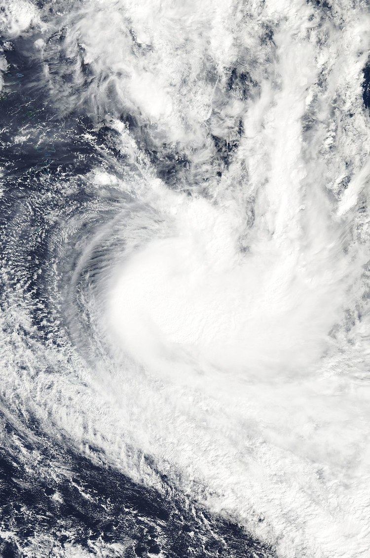
Tropical Cyclone Lin (RSMC Nadi designation: 14F, JTWC Designation: 15P) formed on March 31, 2009 as a tropical depression within a monsoon trough to the northwest of Fiji. Over the next few days, the depression moved towards the southeast through the Fijian archipelago until late on April 3, when the Regional Specialized Meteorological Center in Nadi reported that the depression had intensified into a category one cyclone, and named it Lin. The JTWC did not start issuing warnings on Lin until the next day as it was approaching its 10-minute peak windspeeds of 110 km/h (70 mph) and 1-minute peak windspeeds of 100 km/h (65 mph). Cyclone Lin then reached its peak windspeeds early on April 5 as it passed directly over Tonga. Later that day as it approached the edge of RSMC Nadi's area of responsibility Lin started to go through an extratropical transition with the JTWC issuing their last advisory on it. As it crossed into TCWC Wellington's area of responsibility the cyclone was declared extratropical, however TCWC Wellington kept issuing warnings on Lin until late on April 8.
Contents
In Tonga initial reports, suggested that only vegetation had been impacted. However, it was later reported that power lines had been knocked down by high winds and the heavy rains triggered minor flooding in Nuku'alofa. Power stations in Tongatapu were also forced to close to protect the system. No one was injured by the storm but there were reports of significant crop losses. The Tongan Meteorological Service also reported that about $2,000 2009 TOP, ($1,000 2009 USD) worth of damage had been done to property owned by the service.
Meteorological history
During April 1, RSMC Nadi reported that Tropical Disturbance 14F, had developed along an active monsoon trough to the north of Fiji. During the next day the disturbance gradually developed into a tropical depression, as it moved eastwards and interacted with a shallow tropical disturbance that was located to the east of 14F. The disturbance was subsequently absorbed by 14F’s circulation early on April 3, while the system was located between Tonga and Fiji. Overall organization at this time was still poor with convection struggling to consolidate under shear and diurnal influences. Overnight of the 3rd, though, convection erupted over the centre with the primary band to the east wrapping tightly around the centre. On re-analysis, TD14F attained cyclone status around 031800 UTC while located to the north-northwest of Nukualofa and gradually accelerating towards the southeast. Through April 4, the cyclone moved into minimal shear with good outflow channels aloft. 12 hours later, at 040600 UTC, Lin was upgraded to a storm with 50 knots close to the centre. The cyclone intensified further under favourable conditions and reached a peak intensity of 60 knots while located about 15 nautical miles south-southeast of Nukualofa. As it left Tonga, interaction with drier air and shear increased. This was aided by an approaching upper-trough from the west. At 051800 UTC, intensity was reduced to 45 knots with further weakening anticipated due to stronger shear and cooler waters. Wellington took over warnings for the cyclone from 060000 UTC and downgraded Lin to an extra-tropical system in their first warning. TCWC Wellington subsequently continued to monitor the system until it was last noted on April 8.
Differences among warning centers
The Regional Specialized Meteorological Center in Nadi, Fiji uses the Australian Tropical Cyclone Intensity Scale which is based on 10-minute sustained winds and three second gusts for its tropical cyclone tracking information, while the Joint Typhoon Warning Center uses 1-minute sustained winds. The conversion factor between the two is 1.14. RSMC Nadi's peak intensity for Lin was 110 km/h, (70 mph) 10-minute sustained, or 130 km/h (80 mph) 1-minute sustained. The JTWC's peak intensity for Lin was 95 km/h (60 mph) 1-minute sustained, or 85 km/h (50 mph) 10-minute sustained.
Preparations
Late on April 2, RSMC Nadi reported that a tropical cyclone alert had been issued for Wallis and Futuna and for the whole of Tonga this came as the tropical depression was located about 500 km (310 mi) to the west of Nukualofa. Early the next day RSMC Nadi reported that a tropical cyclone alert had been declared for Vanua Levu, the Lau Islands, Taveuni, as well as other nearby islands, while later that morning Wallis and Futuna were placed under a tropical cyclone warning. Later that day RSMC Nadi reported that Northern Tonga had now been placed under a tropical cyclone warning, while the tropical cyclone alert for Vanua Levu and the cyclone warning for Wallis had been canceled. Later that day as the depression had been relocated and had been named as Cyclone Lin, RSMC Nadi canceled the tropical cyclone alert for Taveuni, and other nearby islands as well as the tropical cyclone warning for Futuna. RSMC Nadi also reported at this time that a tropical cyclone gale warning had been declared for the Lau group and the whole of Tonga. During the next morning the tropical cyclone warnings for the Lau group and the Niuas in Tonga were canceled, while the gale warnings for Tonga were upgraded to storm warnings. Over the next 24 hours the remaining warnings for Tonga were gradually canceled, with the last warning being issued at 1100 UTC on April 5.
Impact
On April 4, Lin passed directly over Tonga with winds up to 110 km/h (70 mph) and heavy rains. Initial reports of damage stated that only vegetation had been impacted. However, later reports stated that power lines had been knocked down by high winds and the heavy rains triggered minor flooding in Nuku'alofa. Some houses lost their rain gutters from the storm. Due to strong winds, officials were forced to shut down power stations in Tongatapu to protect the system. Most of the power lines in Tonga were either downed or damaged by the storm and numerous trees fell across the island. Several roads were also blocked by downed trees and billboards were broken. No one was injured by the storm but there were reports of significant crop losses.
The Tongan Meteorological Service reported that some of its property and equipment had been damaged. The property damage had an approximate value of about $2,000 (2009 TOP, $1,000 2009 USD). This included a Stevenson screen, office guttering, a HF radio antennae, signal processor, and satellite receiver. They also reported that the National weather forecasting center in Fua’amotu had experienced power failure on April 4 at 1600 UTC; for this reason the center operated using a small portable generator until early the next day when they stopped issuing warnings as Lin was no longer a threat to Tonga. Power was eventually restored later that day.