
Topo map USGS Cumbres | Elevation 3,055 m | |
 | ||
Traversed by SH 17, Cumbres & Toltec Scenic Railroad Similar Durango and Silverton, Rocky Mountains, San Juan Mountains, Wolf Creek Pass, Cumbres & Toltec Train | ||
Cumbres Pass, elevation 10,022 ft (3,055 m), is a mountain pass in the San Juan Mountains in Colorado, United States. The pass is traversed by State Highway 17 and the Cumbres and Toltec Scenic Railroad. The highway has a moderate 5.8% approach on the north side and a gentler, 4% approach on the south side. It is rarely closed in winter and does not normally cause problems for vehicles, since the road is not a major through highway.
Map of Cumbres Pass, Colorado 81120, USA
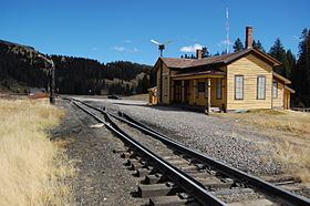
The railroad line was built in the early 1880s by the Denver & Rio Grande Railroad as part of their San Juan Extension line from Alamosa, Colorado to Durango, Colorado. The railroad has a steep (for a railroad) 4% grade approaching from the west, so additional helper locomotives were usually run (and often still are) on trains from Chama to Cumbres Pass. The facilities at the pass were built by the railroad to support the turning of the helper locomotives for their return to Chama, and provide water to locomotives after the climb. Some of the structures at the pass, including the station building, were demolished when the highway was realigned. Regular passenger service was provided by the San Juan Express, running from Alamosa to Durango, and was discontinued in 1951, although numerous rail-fan specials operated over the line until the Fall of 1967. Freight service on the line ended in 1968 and since 1970 the railroad from Chama to Antonito has been owned and operated by the Cumbres and Toltec Scenic Railroad which operates trains over the pass during the tourist season. The original section house, car inspectors house, and part of the old snowshed remain on Cumbres Pass and are maintained by the Friends of the Cumbres and Toltec Scenic Railroad. At present, no one lives at the summit of Cumbres Pass, though when the railroad operated as a common carrier line, railroad personnel were stationed at the pass full-time.
The Pass is on the Continental Divide Trail and represents a transition between states. Northbound hikers head toward Colorado’s San Juan Mountain Wilderness while southbound hikers enter New Mexico’s Carson National Forest. Northbound hikers in the spring, having traveled from the Mexican border, often encounter snowpack in the higher elevations beyond Cumbres Pass, while those southbound hikers arriving from Canada in the fall face increasing colder weather and early snow.