
Country United States County Clinton Time zone Eastern (EST) (UTC-5) Elevation 44 m Population 1,627 (2010) | State New York Town Plattsburgh FIPS code 36-19408 Area 9.3 km² | |
 | ||
Cumberland Head is a census-designated place and region of the town of Plattsburgh in Clinton County, New York, United States. The population was 1,627 at the 2010 census.
Contents
Map of Cumberland Head, NY 12901, USA
Cumberland Head is a peninsula projecting into Lake Champlain, and includes the communities of Rocky Point and Champlain Park.
A landing for the Lake Champlain Transportation Company's ferry to Gordon Landing on Grand Isle, Vermont, is near the south end of Cumberland Head. Cumberland Bay State Park is located at the northern end of the peninsula.
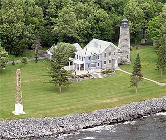
There is a historic lighthouse on the end of Cumberland Head.
Geography
Cumberland Head is located in the northeast part of the town of Plattsburgh at 44°42′59″N 73°24′9″W (44.716345, -73.402603).
According to the United States Census Bureau, the CDP has a total area of 3.6 square miles (9.3 km2), all land.
Demographics
As of the census of 2000, there were 1,532 people, 629 households, and 439 families residing in the CDP. The population density was 413.9 per square mile (159.9/km²). There were 793 housing units at an average density of 214.3/sq mi (82.8/km²). The racial makeup of the CDP was 96.08% White, 1.50% African American, 0.33% Native American, 0.33% Asian, 0.07% Pacific Islander, 0.59% from other races, and 1.11% from two or more races. Hispanic or Latino of any race were 0.91% of the population. Common ancestries included English (18.8%), French (17.6%), Irish (15.6%), French Canadian (12.6%), Polish (7.4%), and a few Italian-American families.
There were 629 households out of which 29.9% had children under the age of 18 living with them, 58.8% were married couples living together, 7.2% had a female householder with no husband present, and 30.2% were non-families. 23.2% of all households were made up of individuals and 8.1% had someone living alone who was 65 years of age or older. The average household size was 2.44 and the average family size was 2.89.
In the CDP, the population was spread out with 24.0% under the age of 18, 4.7% from 18 to 24, 28.6% from 25 to 44, 28.9% from 45 to 64, and 13.9% who were 65 years of age or older. The median age was 41 years. For every 100 females there were 99.5 males. For every 100 females age 18 and over, there were 99.1 males.
The median income for a household in the CDP was $54,659, and the median income for a family was $62,434. Males had a median income of $41,100 versus $27,438 for females. The per capita income for the CDP was $29,092. About 1.7% of families and 3.5% of the population were below the poverty line, including none of those under age 18 and 21.5% of those age 65 or over.