
Country United States FIPS code 40-18450 Elevation 293 m Zip code 74837 Local time Saturday 2:07 PM | Time zone Central (CST) (UTC-6) GNIS feature ID 1091830 Area 2.8 km² Population 287 (2013) Area code 405 | |
 | ||
Weather 18°C, Wind S at 32 km/h, 31% Humidity | ||
Cromwell is a town in Seminole County, Oklahoma, United States. The population was 286 at the 2010 census, an 8 percent increase from 265 at the 2000 census. It was named for oilman Joe I. Cromwell, who platted the original town in 1923. The population exploded to a few thousand people in a few weeks, and lawlessness was rampant in the community. Retired legendary Old West lawman Bill Tilghman was hired as Town Marshall to restore order. Tilghman was shot to death the following year, the most notable event in Cromwell's history.
Contents
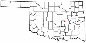
Map of Cromwell, OK, USA
History
Founded in 1923, and named for Muskogee oilman, Joe I. Cromwell, Cromwell had a post office on May 17, 1924.
Cromwell was a wild and wooly town in the early 1920s. The town was said to be full of saloons, brothels and outlaws. About 150 businesses operated in Cromwell during the 1920s, many selling moonshine alcohol and narcotics to residents of the surrounding area. However, about seventy of these were permanently closed during an enforcement drive. The illegal sales continued because a Federal revenue agent named Wiley Lynn was connected to mobster Arnold Killian.
On Halloween night, 1924, Cromwell Town Marshal and legendary Old West lawman Bill Tilghman was shot outside of a cafe called "Ma Murphy's", by the corrupt prohibition agent Wiley Lynn. Tilghman died in the early morning hours of the first of November. Tilghman had been brought in to help bring the town under control. One month later the town of Cromwell was torched, with every brothel, bar, flop house and pool hall burned to the ground, allegedly by friends of Tilghman. There was no investigation into the massive fire, and Cromwell never recovered its former wild status, or size.
Geography
Cromwell is located at 35°21′1″N 96°27′35″W (35.350195, -96.459700). According to the United States Census Bureau, the town has a total area of 1.1 square miles (2.8 km2), all of it land.
Demographics
As of the census of 2000, there were 265 people, 97 households, and 77 families residing in the town. The population density was 247.7 people per square mile (95.6/km²). There were 113 housing units at an average density of 105.6 per square mile (40.8/km²). The racial makeup of the town was 71.70% White, 0.75% African American, 19.25% Native American, 3.02% from other races, and 5.28% from two or more races. Hispanic or Latino of any race were 3.02% of the population.
There were 97 households out of which 36.1% had children under the age of 18 living with them, 57.7% were married couples living together, 15.5% had a female householder with no husband present, and 20.6% were non-families. 17.5% of all households were made up of individuals and 11.3% had someone living alone who was 65 years of age or older. The average household size was 2.73 and the average family size was 3.08.
In the town, the population was spread out with 29.1% under the age of 18, 4.9% from 18 to 24, 24.2% from 25 to 44, 26.8% from 45 to 64, and 15.1% who were 65 years of age or older. The median age was 40 years. For every 100 females there were 84.0 males. For every 100 females age 18 and over, there were 84.3 males.
The median income for a household in the town was $30,833, and the median income for a family was $31,607. Males had a median income of $18,750 versus $21,250 for females. The per capita income for the town was $12,751. About 15.2% of families and 20.1% of the population were below the poverty line, including 30.0% of those under the age of eighteen and none of those sixty five or over.