
Location Arafura Sea Length 43 km (26.7 mi) Highest elevation 15 m (49 ft) Elevation 15 m | Major islands Croker, Darch, Templer Width 15 km (9.3 mi) Territory Northern Territory Area 331.5 km² | |
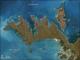 | ||
Croker Island is an island in the Arafura Sea off the coast of the Northern Territory, Australia, 200 km northeast of Darwin. It is separated from Cobourg Peninsula in the west by Bowen Strait, which is 2.5 km wide in the south and up to 7 km in the north, and 8.5 km long. In the north and east is the Arafura Sea, and in the south and southeast Mountnorris Bay. Croker Island measures 43 km from Point David (south, local name Inngirnatj) to Cape Croker (north), up to 15 km wide, and has an area of 331.5 km² (128.0 sq. miles). At its highest point it is only 15 m (50 feet) above sea level. Croker Island is the largest island, and the only permanently inhabited island, in the Croker Group.
Contents
- Map of Croker Island Northern Territory 0822 Australia
- Settlement
- Croker Island Native Title Claim
- Environment
- References
Map of Croker Island, Northern Territory 0822, Australia
Settlement
The only notable settlement on Croker Island is the Aboriginal community of Minjilang, located on Mission Bay on the east coast. Apart from that, there are nine small family outstations, the largest ones of which is Inngirnatj (Point David) at the southern end of the island. The settlements from north to south:
- Alamirra (close to Somerville Bay 1.5 km further the north)
- Timor Springs (north of Minjilang, 8 km by road)
- Wanakutja (on Palm Bay in the north-west)
- Minjilang (Mission Bay), the only village and main settlement of the island
- Adjamarrago (800 metres north of Croker Island Aerodrome, west of Minjilang)
- Keith William's Outstation (Arrgamumu, Arrgamurrmur) (south-east of Mission Bay)
- Walka (Barge Landing) (south side of Mission Bay, with barge pier)
- Sandy Bay (close to Sandy Bay on the east coast, but two kilometres to the coast)
- Marramarrani (southwest coast)
- Inngirnatj (Point David) (southern end, west side, with boat pier)
Croker Island Native Title Claim
The Traditional Owners of Croker Island, the Yarmirr people, filed a claim over the sea surrounding Croker Island. The case, Yarmirr v Northern Territory, was settled in the High Court of Australia on 11 October 2001. The case established that the Yarmirr people do have native title of the sea and sea-bed, however common law rights of fishing and navigation mean that only non-exclusive native title can exist over the sea.
Environment
Croker Island was severely damaged by Cyclone Ingrid in March 2005.
A cull of feral horses was undertaken in 2015.