
Main source Zeleznec Length 207 km Source Drugovo Municipality Country Macedonia (FYROM) | River mouth Vardar Source elevation 760 m Mouth Vardar | |
 | ||
Similar Tikveš, Baba Mountain, Skopska Crna Gora, Kožuf, Lepenac | ||
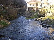
The Crna (Macedonian: Црна), also Crna Reka (Macedonian: Црна Река ) is a river in the Republic of Macedonia. It is the right tributary of the Vardar river. It runs though much of the south and west of the country. Its source is in the mountains of western Macedonia, west of Kruševo. It flows through the village Sopotnica, and southwards through the plains east of Bitola. At Brod (Novaci Municipality) it turns northeast, and it flows into the Vardar between Rosoman and Gradsko.
Map of Crna Reka, Macedonia (FYROM)
Thus, the river makes a bend of almost 180 degrees east of Bitola. This bend was part of the Macedonian Front in World War I. It was known to the allied forces as the Cerna Bend or Cerna Loop, and two major battles were fought here : the Battle of the Cerna Bend (1916) and the Battle of the Cerna Bend (1917).
The name Crna Reka means "Black river" in Macedonian, a translation of its earlier Thracian name, Erigon, meaning "black", akin to Greek érebos, "darkness"; Armenian erek, "evening"; Old Norse røkkr, "darkness"; Gothic riqis, "darkness"; Sanskrit rájas, "night"; Tocharian B orkamo, "dark".